You are here: Home > Network List > TA - USArray Transportable Network (new EarthScope stations) Stations List
> Station T38A Diamond, MO, USA > Earthquake Result Viewer
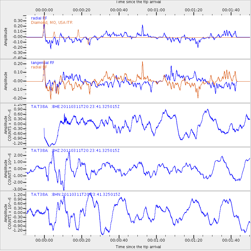
T38A Diamond, MO, USA - Earthquake Result Viewer
*The percent match for this event was below the threshold and hence no stack was calculated.
| Earthquake location: |
Near East Coast Of Honshu, Japan |
| Earthquake latitude/longitude: |
39.0/142.6 |
| Earthquake time(UTC): |
2011/03/11 (070) 20:11:24 GMT |
| Earthquake Depth: |
17 km |
| Earthquake Magnitude: |
5.9 MB, 5.8 MS, 6.1 MW |
| Earthquake Catalog/Contributor: |
WHDF/NEIC |
|
| Network: |
TA USArray Transportable Network (new EarthScope stations) |
| Station: |
T38A Diamond, MO, USA |
| Lat/Lon: |
37.04 N/94.29 W |
| Elevation: |
349 m |
|
| Distance: |
88.0 deg |
| Az: |
42.142 deg |
| Baz: |
319.208 deg |
| Ray Param: |
$rayparam |
*The percent match for this event was below the threshold and hence was not used in the summary stack. |
|
| Radial Match: |
43.890724 % |
| Radial Bump: |
400 |
| Transverse Match: |
47.02025 % |
| Transverse Bump: |
400 |
| SOD ConfigId: |
356183 |
| Insert Time: |
2011-08-18 12:38:46.874 +0000 |
| GWidth: |
2.5 |
| Max Bumps: |
400 |
| Tol: |
0.001 |
|
Signal To Noise
| Channel | StoN | STA | LTA |
| TA:T38A: :BHZ:20110311T20:23:41.325015Z | 2.7604814 | 1.1663562E-6 | 4.2251915E-7 |
| TA:T38A: :BHN:20110311T20:23:41.325015Z | 2.4114933 | 5.711195E-7 | 2.3683229E-7 |
| TA:T38A: :BHE:20110311T20:23:41.325015Z | 0.5701614 | 3.532955E-7 | 6.1964124E-7 |
| Arrivals |
| Ps | |
| PpPs | |
| PsPs/PpSs | |


