You are here: Home > Network List > TA - USArray Transportable Network (new EarthScope stations) Stations List
> Station H57A Richville, NY, USA > Earthquake Result Viewer
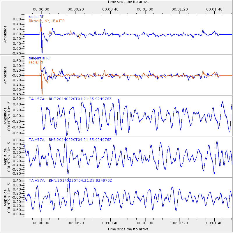
H57A Richville, NY, USA - Earthquake Result Viewer
*The percent match for this event was below the threshold and hence no stack was calculated.
| Earthquake location: |
Southern Mid-Atlantic Ridge |
| Earthquake latitude/longitude: |
-14.1/-14.6 |
| Earthquake time(UTC): |
2014/02/20 (051) 04:09:57 GMT |
| Earthquake Depth: |
14 km |
| Earthquake Magnitude: |
5.1 MW |
| Earthquake Catalog/Contributor: |
ISC/ISC |
|
| Network: |
TA USArray Transportable Network (new EarthScope stations) |
| Station: |
H57A Richville, NY, USA |
| Lat/Lon: |
44.46 N/75.39 W |
| Elevation: |
132 m |
|
| Distance: |
80.3 deg |
| Az: |
320.637 deg |
| Baz: |
120.773 deg |
| Ray Param: |
$rayparam |
*The percent match for this event was below the threshold and hence was not used in the summary stack. |
|
| Radial Match: |
63.741333 % |
| Radial Bump: |
400 |
| Transverse Match: |
58.582165 % |
| Transverse Bump: |
400 |
| SOD ConfigId: |
3390531 |
| Insert Time: |
2019-04-10 09:47:44.354 +0000 |
| GWidth: |
2.5 |
| Max Bumps: |
400 |
| Tol: |
0.001 |
|
Signal To Noise
| Channel | StoN | STA | LTA |
| TA:H57A: :BHZ:20140220T04:21:35.924976Z | 0.63613105 | 2.602391E-7 | 4.0909666E-7 |
| TA:H57A: :BHN:20140220T04:21:35.924976Z | 1.2138213 | 3.088548E-7 | 2.5444834E-7 |
| TA:H57A: :BHE:20140220T04:21:35.924976Z | 0.86800444 | 2.618195E-7 | 3.0163386E-7 |
| Arrivals |
| Ps | |
| PpPs | |
| PsPs/PpSs | |


