You are here: Home > Network List > US - United States National Seismic Network Stations List
> Station EGMT Eagleton, Montana, USA > Earthquake Result Viewer
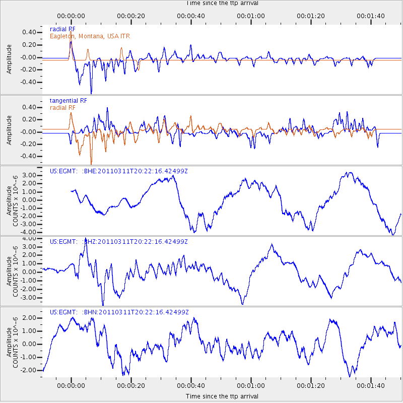
EGMT Eagleton, Montana, USA - Earthquake Result Viewer
*The percent match for this event was below the threshold and hence no stack was calculated.
| Earthquake location: |
Near East Coast Of Honshu, Japan |
| Earthquake latitude/longitude: |
39.0/142.6 |
| Earthquake time(UTC): |
2011/03/11 (070) 20:11:24 GMT |
| Earthquake Depth: |
17 km |
| Earthquake Magnitude: |
5.9 MB, 5.8 MS, 6.1 MW |
| Earthquake Catalog/Contributor: |
WHDF/NEIC |
|
| Network: |
US United States National Seismic Network |
| Station: |
EGMT Eagleton, Montana, USA |
| Lat/Lon: |
48.02 N/109.75 W |
| Elevation: |
1055 m |
|
| Distance: |
72.2 deg |
| Az: |
42.233 deg |
| Baz: |
308.727 deg |
| Ray Param: |
$rayparam |
*The percent match for this event was below the threshold and hence was not used in the summary stack. |
|
| Radial Match: |
78.60895 % |
| Radial Bump: |
354 |
| Transverse Match: |
70.097984 % |
| Transverse Bump: |
364 |
| SOD ConfigId: |
356183 |
| Insert Time: |
2011-08-18 12:46:22.540 +0000 |
| GWidth: |
2.5 |
| Max Bumps: |
400 |
| Tol: |
0.001 |
|
Signal To Noise
| Channel | StoN | STA | LTA |
| US:EGMT: :BHZ:20110311T20:22:16.42499Z | 2.7448418 | 1.710915E-6 | 6.233201E-7 |
| US:EGMT: :BHN:20110311T20:22:16.42499Z | 1.5143852 | 2.0962086E-6 | 1.3841977E-6 |
| US:EGMT: :BHE:20110311T20:22:16.42499Z | 3.6895843 | 2.9392897E-6 | 7.966452E-7 |
| Arrivals |
| Ps | |
| PpPs | |
| PsPs/PpSs | |


