You are here: Home > Network List > TA - USArray Transportable Network (new EarthScope stations) Stations List
> Station P56A Dayton Farm, Ripley, WV, USA > Earthquake Result Viewer
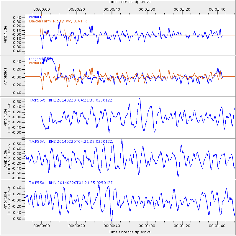
P56A Dayton Farm, Ripley, WV, USA - Earthquake Result Viewer
*The percent match for this event was below the threshold and hence no stack was calculated.
| Earthquake location: |
Southern Mid-Atlantic Ridge |
| Earthquake latitude/longitude: |
-14.1/-14.6 |
| Earthquake time(UTC): |
2014/02/20 (051) 04:09:57 GMT |
| Earthquake Depth: |
14 km |
| Earthquake Magnitude: |
5.1 MW |
| Earthquake Catalog/Contributor: |
ISC/ISC |
|
| Network: |
TA USArray Transportable Network (new EarthScope stations) |
| Station: |
P56A Dayton Farm, Ripley, WV, USA |
| Lat/Lon: |
39.50 N/78.84 W |
| Elevation: |
249 m |
|
| Distance: |
80.1 deg |
| Az: |
314.976 deg |
| Baz: |
117.505 deg |
| Ray Param: |
$rayparam |
*The percent match for this event was below the threshold and hence was not used in the summary stack. |
|
| Radial Match: |
58.704834 % |
| Radial Bump: |
400 |
| Transverse Match: |
55.597523 % |
| Transverse Bump: |
400 |
| SOD ConfigId: |
3390531 |
| Insert Time: |
2019-04-10 09:48:10.347 +0000 |
| GWidth: |
2.5 |
| Max Bumps: |
400 |
| Tol: |
0.001 |
|
Signal To Noise
| Channel | StoN | STA | LTA |
| TA:P56A: :BHZ:20140220T04:21:35.025012Z | 1.0969582 | 2.1785922E-7 | 1.9860303E-7 |
| TA:P56A: :BHN:20140220T04:21:35.025012Z | 0.9825022 | 2.2908628E-7 | 2.3316616E-7 |
| TA:P56A: :BHE:20140220T04:21:35.025012Z | 1.1940012 | 2.242202E-7 | 1.8778893E-7 |
| Arrivals |
| Ps | |
| PpPs | |
| PsPs/PpSs | |


