You are here: Home > Network List > TA - USArray Transportable Network (new EarthScope stations) Stations List
> Station X33A Lawton, OK, USA > Earthquake Result Viewer
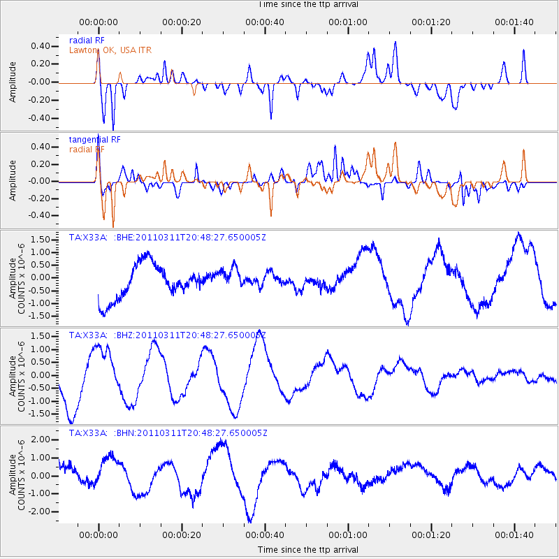
X33A Lawton, OK, USA - Earthquake Result Viewer
*The percent match for this event was below the threshold and hence no stack was calculated.
| Earthquake location: |
Off East Coast Of Honshu, Japan |
| Earthquake latitude/longitude: |
37.8/142.8 |
| Earthquake time(UTC): |
2011/03/11 (070) 20:36:10 GMT |
| Earthquake Depth: |
26 km |
| Earthquake Magnitude: |
5.5 MB |
| Earthquake Catalog/Contributor: |
WHDF/NEIC |
|
| Network: |
TA USArray Transportable Network (new EarthScope stations) |
| Station: |
X33A Lawton, OK, USA |
| Lat/Lon: |
34.54 N/98.50 W |
| Elevation: |
346 m |
|
| Distance: |
88.2 deg |
| Az: |
46.438 deg |
| Baz: |
315.966 deg |
| Ray Param: |
$rayparam |
*The percent match for this event was below the threshold and hence was not used in the summary stack. |
|
| Radial Match: |
74.271645 % |
| Radial Bump: |
400 |
| Transverse Match: |
63.558952 % |
| Transverse Bump: |
400 |
| SOD ConfigId: |
356183 |
| Insert Time: |
2011-08-18 14:47:22.371 +0000 |
| GWidth: |
2.5 |
| Max Bumps: |
400 |
| Tol: |
0.001 |
|
Signal To Noise
| Channel | StoN | STA | LTA |
| TA:X33A: :BHZ:20110311T20:48:27.650005Z | 0.9438337 | 9.273251E-7 | 9.82509E-7 |
| TA:X33A: :BHN:20110311T20:48:27.650005Z | 1.7949632 | 1.0308461E-6 | 5.742993E-7 |
| TA:X33A: :BHE:20110311T20:48:27.650005Z | 0.6734884 | 4.4474854E-7 | 6.603656E-7 |
| Arrivals |
| Ps | |
| PpPs | |
| PsPs/PpSs | |


