You are here: Home > Network List > TA - USArray Transportable Network (new EarthScope stations) Stations List
> Station G03D McMinnville, OR, USA > Earthquake Result Viewer
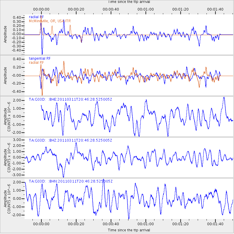
G03D McMinnville, OR, USA - Earthquake Result Viewer
*The percent match for this event was below the threshold and hence no stack was calculated.
| Earthquake location: |
Off East Coast Of Honshu, Japan |
| Earthquake latitude/longitude: |
37.8/142.8 |
| Earthquake time(UTC): |
2011/03/11 (070) 20:36:10 GMT |
| Earthquake Depth: |
26 km |
| Earthquake Magnitude: |
5.5 MB |
| Earthquake Catalog/Contributor: |
WHDF/NEIC |
|
| Network: |
TA USArray Transportable Network (new EarthScope stations) |
| Station: |
G03D McMinnville, OR, USA |
| Lat/Lon: |
45.21 N/123.26 W |
| Elevation: |
222 m |
|
| Distance: |
66.8 deg |
| Az: |
50.107 deg |
| Baz: |
300.744 deg |
| Ray Param: |
$rayparam |
*The percent match for this event was below the threshold and hence was not used in the summary stack. |
|
| Radial Match: |
58.606487 % |
| Radial Bump: |
400 |
| Transverse Match: |
44.78022 % |
| Transverse Bump: |
400 |
| SOD ConfigId: |
356183 |
| Insert Time: |
2011-08-18 14:47:46.066 +0000 |
| GWidth: |
2.5 |
| Max Bumps: |
400 |
| Tol: |
0.001 |
|
Signal To Noise
| Channel | StoN | STA | LTA |
| TA:G03D: :BHZ:20110311T20:46:28.525005Z | 1.6362653 | 1.3498254E-6 | 8.2494284E-7 |
| TA:G03D: :BHN:20110311T20:46:28.525005Z | 1.0858015 | 9.932353E-7 | 9.1474845E-7 |
| TA:G03D: :BHE:20110311T20:46:28.525005Z | 1.1073422 | 9.995717E-7 | 9.0267645E-7 |
| Arrivals |
| Ps | |
| PpPs | |
| PsPs/PpSs | |


