You are here: Home > Network List > TA - USArray Transportable Network (new EarthScope stations) Stations List
> Station 636A Smothers Creek Ranch, Halletsville, TX, USA > Earthquake Result Viewer
636A Smothers Creek Ranch, Halletsville, TX, USA - Earthquake Result Viewer
| Earthquake location: |
Off East Coast Of Honshu, Japan |
| Earthquake latitude/longitude: |
37.8/142.8 |
| Earthquake time(UTC): |
2011/03/11 (070) 20:36:10 GMT |
| Earthquake Depth: |
26 km |
| Earthquake Magnitude: |
5.5 MB |
| Earthquake Catalog/Contributor: |
WHDF/NEIC |
|
| Network: |
TA USArray Transportable Network (new EarthScope stations) |
| Station: |
636A Smothers Creek Ranch, Halletsville, TX, USA |
| Lat/Lon: |
29.48 N/97.06 W |
| Elevation: |
90 m |
|
| Distance: |
92.7 deg |
| Az: |
49.033 deg |
| Baz: |
316.708 deg |
| Ray Param: |
0.041396294 |
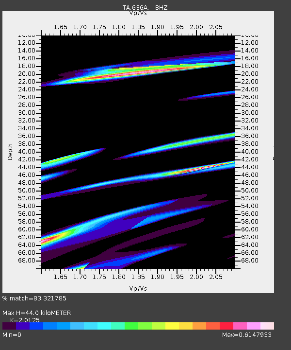
| Estimated Moho Depth: |
44.0 km |
| Estimated Crust Vp/Vs: |
2.01 |
| Assumed Crust Vp: |
5.78 km/s |
| Estimated Crust Vs: |
2.872 km/s |
| Estimated Crust Poisson's Ratio: |
0.34 |
|
| Radial Match: |
83.321785 % |
| Radial Bump: |
400 |
| Transverse Match: |
59.75345 % |
| Transverse Bump: |
400 |
| SOD ConfigId: |
356183 |
| Insert Time: |
2011-08-18 14:51:08.505 +0000 |
| GWidth: |
2.5 |
| Max Bumps: |
400 |
| Tol: |
0.001 |
|

Signal To Noise
| Channel | StoN | STA | LTA |
| TA:636A: :BHZ:20110311T20:48:48.49998Z | 2.2027004 | 1.923992E-6 | 8.734697E-7 |
| TA:636A: :BHN:20110311T20:48:48.49998Z | 2.1105447 | 2.674204E-6 | 1.2670681E-6 |
| TA:636A: :BHE:20110311T20:48:48.49998Z | 0.8265452 | 1.944089E-6 | 2.3520663E-6 |
| Arrivals |
| Ps | 7.8 SECOND |
| PpPs | 23 SECOND |
| PsPs/PpSs | 30 SECOND |


