You are here: Home > Network List > TA - USArray Transportable Network (new EarthScope stations) Stations List
> Station 337A Centerville, TX, USA > Earthquake Result Viewer
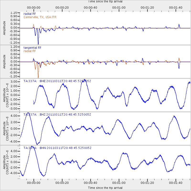
337A Centerville, TX, USA - Earthquake Result Viewer
*The percent match for this event was below the threshold and hence no stack was calculated.
| Earthquake location: |
Off East Coast Of Honshu, Japan |
| Earthquake latitude/longitude: |
37.8/142.8 |
| Earthquake time(UTC): |
2011/03/11 (070) 20:36:10 GMT |
| Earthquake Depth: |
26 km |
| Earthquake Magnitude: |
5.5 MB |
| Earthquake Catalog/Contributor: |
WHDF/NEIC |
|
| Network: |
TA USArray Transportable Network (new EarthScope stations) |
| Station: |
337A Centerville, TX, USA |
| Lat/Lon: |
31.32 N/95.89 W |
| Elevation: |
150 m |
|
| Distance: |
92.1 deg |
| Az: |
47.044 deg |
| Baz: |
317.38 deg |
| Ray Param: |
$rayparam |
*The percent match for this event was below the threshold and hence was not used in the summary stack. |
|
| Radial Match: |
85.133286 % |
| Radial Bump: |
400 |
| Transverse Match: |
65.24211 % |
| Transverse Bump: |
400 |
| SOD ConfigId: |
356183 |
| Insert Time: |
2011-08-18 14:51:31.545 +0000 |
| GWidth: |
2.5 |
| Max Bumps: |
400 |
| Tol: |
0.001 |
|
Signal To Noise
| Channel | StoN | STA | LTA |
| TA:337A: :BHZ:20110311T20:48:45.525005Z | 1.4092252 | 3.333694E-6 | 2.3656219E-6 |
| TA:337A: :BHN:20110311T20:48:45.525005Z | 1.9900408 | 4.016961E-6 | 2.018532E-6 |
| TA:337A: :BHE:20110311T20:48:45.525005Z | 1.4030501 | 2.3501818E-6 | 1.675052E-6 |
| Arrivals |
| Ps | |
| PpPs | |
| PsPs/PpSs | |


