You are here: Home > Network List > TA - USArray Transportable Network (new EarthScope stations) Stations List
> Station O03D Paynes Creek, CA, USA > Earthquake Result Viewer
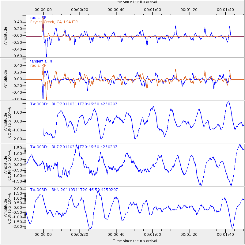
O03D Paynes Creek, CA, USA - Earthquake Result Viewer
*The percent match for this event was below the threshold and hence no stack was calculated.
| Earthquake location: |
Off East Coast Of Honshu, Japan |
| Earthquake latitude/longitude: |
37.8/142.8 |
| Earthquake time(UTC): |
2011/03/11 (070) 20:36:10 GMT |
| Earthquake Depth: |
26 km |
| Earthquake Magnitude: |
5.5 MB |
| Earthquake Catalog/Contributor: |
WHDF/NEIC |
|
| Network: |
TA USArray Transportable Network (new EarthScope stations) |
| Station: |
O03D Paynes Creek, CA, USA |
| Lat/Lon: |
40.29 N/121.80 W |
| Elevation: |
968 m |
|
| Distance: |
70.3 deg |
| Az: |
53.973 deg |
| Baz: |
303.148 deg |
| Ray Param: |
$rayparam |
*The percent match for this event was below the threshold and hence was not used in the summary stack. |
|
| Radial Match: |
61.687805 % |
| Radial Bump: |
400 |
| Transverse Match: |
41.77965 % |
| Transverse Bump: |
400 |
| SOD ConfigId: |
356183 |
| Insert Time: |
2011-08-18 14:57:29.748 +0000 |
| GWidth: |
2.5 |
| Max Bumps: |
400 |
| Tol: |
0.001 |
|
Signal To Noise
| Channel | StoN | STA | LTA |
| TA:O03D: :BHZ:20110311T20:46:50.425029Z | 0.7399631 | 5.272426E-7 | 7.1252555E-7 |
| TA:O03D: :BHN:20110311T20:46:50.425029Z | 0.8462852 | 6.981304E-7 | 8.249351E-7 |
| TA:O03D: :BHE:20110311T20:46:50.425029Z | 1.1144732 | 1.0120468E-6 | 9.0809436E-7 |
| Arrivals |
| Ps | |
| PpPs | |
| PsPs/PpSs | |


