You are here: Home > Network List > TA - USArray Transportable Network (new EarthScope stations) Stations List
> Station A33A Warroad, MN, USA > Earthquake Result Viewer
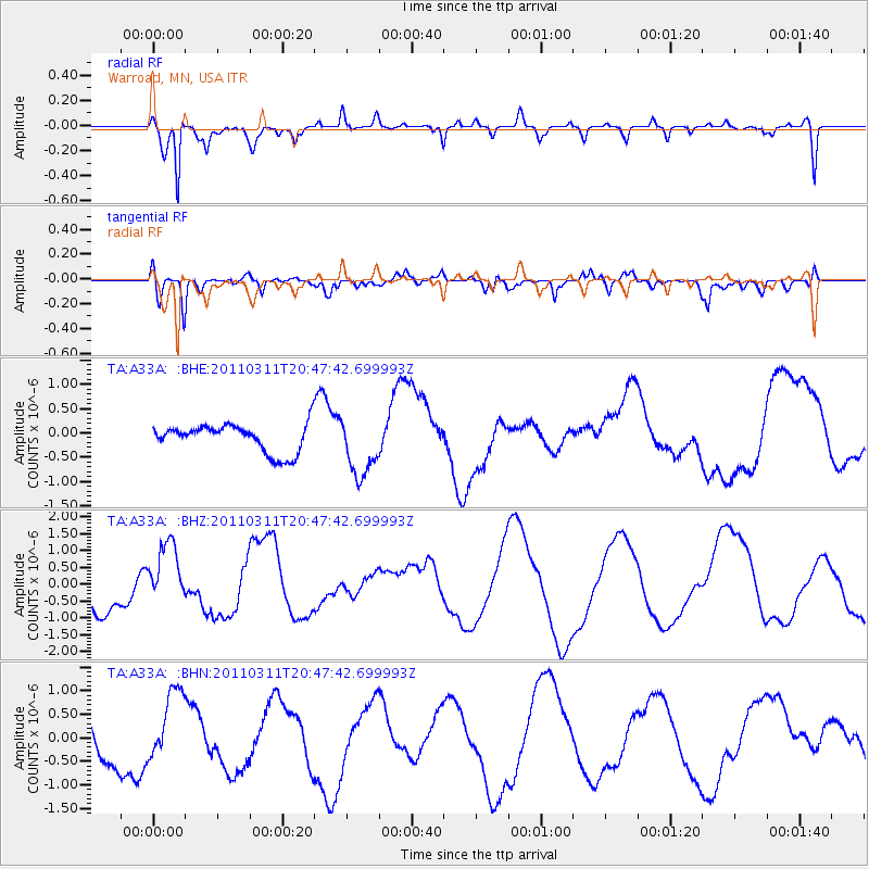
A33A Warroad, MN, USA - Earthquake Result Viewer
*The percent match for this event was below the threshold and hence no stack was calculated.
| Earthquake location: |
Off East Coast Of Honshu, Japan |
| Earthquake latitude/longitude: |
37.8/142.8 |
| Earthquake time(UTC): |
2011/03/11 (070) 20:36:10 GMT |
| Earthquake Depth: |
26 km |
| Earthquake Magnitude: |
5.5 MB |
| Earthquake Catalog/Contributor: |
WHDF/NEIC |
|
| Network: |
TA USArray Transportable Network (new EarthScope stations) |
| Station: |
A33A Warroad, MN, USA |
| Lat/Lon: |
48.94 N/95.39 W |
| Elevation: |
329 m |
|
| Distance: |
79.4 deg |
| Az: |
34.77 deg |
| Baz: |
316.779 deg |
| Ray Param: |
$rayparam |
*The percent match for this event was below the threshold and hence was not used in the summary stack. |
|
| Radial Match: |
61.804165 % |
| Radial Bump: |
374 |
| Transverse Match: |
55.669388 % |
| Transverse Bump: |
400 |
| SOD ConfigId: |
356183 |
| Insert Time: |
2011-08-18 15:02:29.469 +0000 |
| GWidth: |
2.5 |
| Max Bumps: |
400 |
| Tol: |
0.001 |
|
Signal To Noise
| Channel | StoN | STA | LTA |
| TA:A33A: :BHZ:20110311T20:47:42.699993Z | 1.5799221 | 9.775163E-7 | 6.187117E-7 |
| TA:A33A: :BHN:20110311T20:47:42.699993Z | 1.0806345 | 7.215656E-7 | 6.6772407E-7 |
| TA:A33A: :BHE:20110311T20:47:42.699993Z | 2.1365545 | 6.226725E-7 | 2.914377E-7 |
| Arrivals |
| Ps | |
| PpPs | |
| PsPs/PpSs | |


