You are here: Home > Network List > TA - USArray Transportable Network (new EarthScope stations) Stations List
> Station P29A Atwood, KS, USA > Earthquake Result Viewer
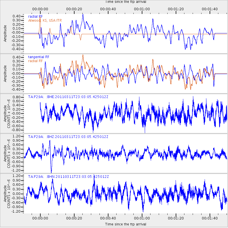
P29A Atwood, KS, USA - Earthquake Result Viewer
*The percent match for this event was below the threshold and hence no stack was calculated.
| Earthquake location: |
Off East Coast Of Honshu, Japan |
| Earthquake latitude/longitude: |
37.8/144.8 |
| Earthquake time(UTC): |
2011/03/11 (070) 22:51:19 GMT |
| Earthquake Depth: |
39 km |
| Earthquake Magnitude: |
5.7 MB |
| Earthquake Catalog/Contributor: |
WHDF/NEIC |
|
| Network: |
TA USArray Transportable Network (new EarthScope stations) |
| Station: |
P29A Atwood, KS, USA |
| Lat/Lon: |
39.60 N/100.93 W |
| Elevation: |
929 m |
|
| Distance: |
82.1 deg |
| Az: |
45.327 deg |
| Baz: |
313.214 deg |
| Ray Param: |
$rayparam |
*The percent match for this event was below the threshold and hence was not used in the summary stack. |
|
| Radial Match: |
53.01766 % |
| Radial Bump: |
400 |
| Transverse Match: |
57.33614 % |
| Transverse Bump: |
400 |
| SOD ConfigId: |
356183 |
| Insert Time: |
2011-08-18 16:19:44.033 +0000 |
| GWidth: |
2.5 |
| Max Bumps: |
400 |
| Tol: |
0.001 |
|
Signal To Noise
| Channel | StoN | STA | LTA |
| TA:P29A: :BHZ:20110311T23:03:05.425012Z | 1.2579015 | 2.6786444E-7 | 2.1294548E-7 |
| TA:P29A: :BHN:20110311T23:03:05.425012Z | 1.7881947 | 4.797252E-7 | 2.6827345E-7 |
| TA:P29A: :BHE:20110311T23:03:05.425012Z | 1.8258424 | 4.158331E-7 | 2.2774864E-7 |
| Arrivals |
| Ps | |
| PpPs | |
| PsPs/PpSs | |


