You are here: Home > Network List > CI - Caltech Regional Seismic Network Stations List
> Station LGU LGU, Camarillo, CA, USA > Earthquake Result Viewer
LGU LGU, Camarillo, CA, USA - Earthquake Result Viewer
| Earthquake location: |
Vanuatu Islands |
| Earthquake latitude/longitude: |
-14.8/167.4 |
| Earthquake time(UTC): |
2006/03/07 (066) 06:28:55 GMT |
| Earthquake Depth: |
136 km |
| Earthquake Magnitude: |
5.7 MB, 6.2 MW, 6.1 MW |
| Earthquake Catalog/Contributor: |
WHDF/NEIC |
|
| Network: |
CI Caltech Regional Seismic Network |
| Station: |
LGU LGU, Camarillo, CA, USA |
| Lat/Lon: |
34.11 N/119.07 W |
| Elevation: |
416 m |
|
| Distance: |
85.1 deg |
| Az: |
53.01 deg |
| Baz: |
248.607 deg |
| Ray Param: |
0.04469587 |
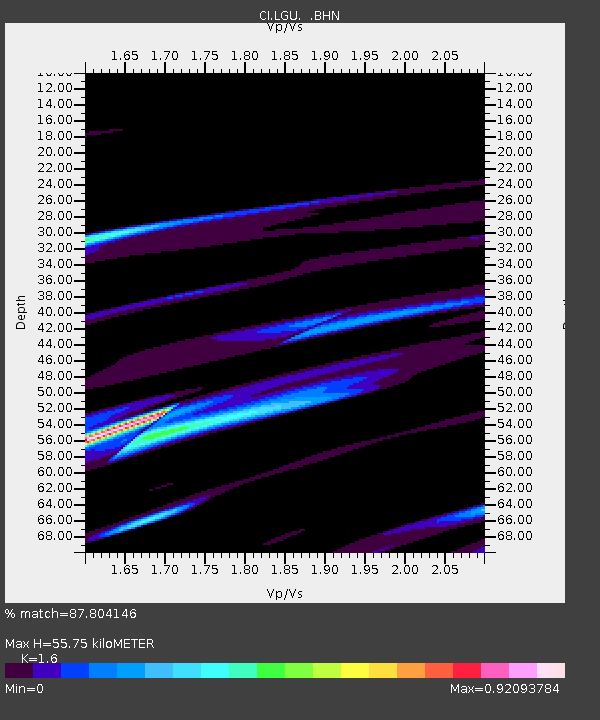
| Estimated Moho Depth: |
55.75 km |
| Estimated Crust Vp/Vs: |
1.60 |
| Assumed Crust Vp: |
6.1 km/s |
| Estimated Crust Vs: |
3.812 km/s |
| Estimated Crust Poisson's Ratio: |
0.18 |
|
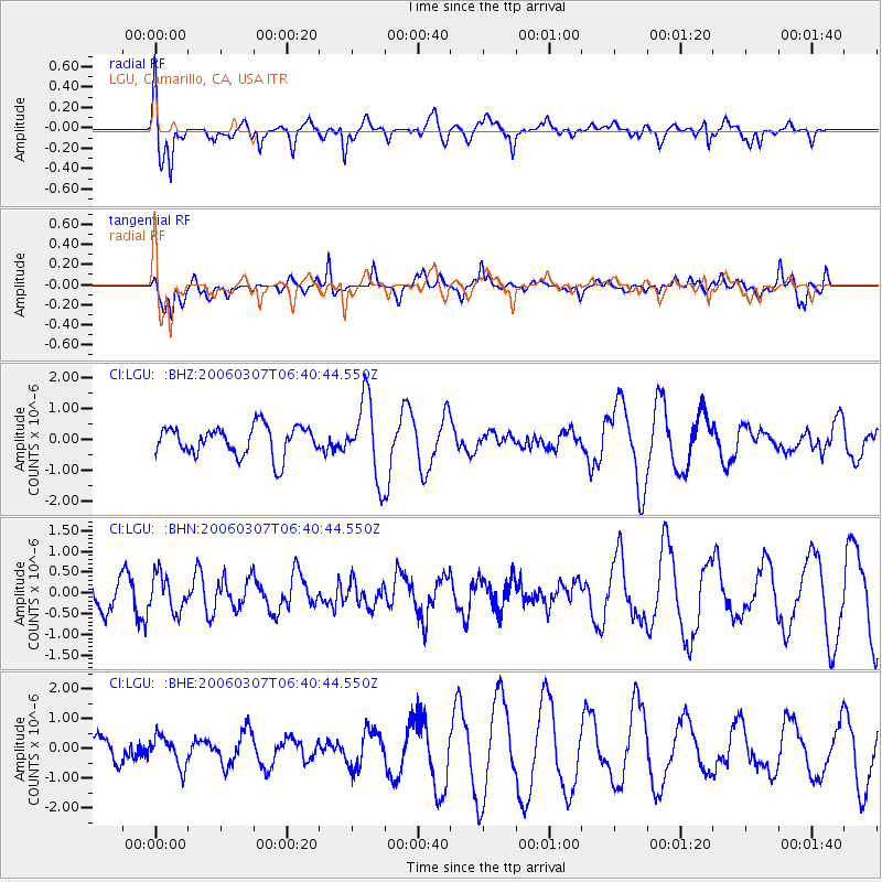
| Radial Match: |
87.804146 % |
| Radial Bump: |
400 |
| Transverse Match: |
67.449425 % |
| Transverse Bump: |
400 |
| SOD ConfigId: |
2422 |
| Insert Time: |
2010-02-25 20:13:55.303 +0000 |
| GWidth: |
2.5 |
| Max Bumps: |
400 |
| Tol: |
0.001 |
|
Signal To Noise
| Channel | StoN | STA | LTA |
| CI:LGU: :BHN:20060307T06:40:44.550Z | 1.4197993 | 4.3741323E-7 | 3.08081E-7 |
| CI:LGU: :BHE:20060307T06:40:44.550Z | 1.1048071 | 5.051573E-7 | 4.5723573E-7 |
| CI:LGU: :BHZ:20060307T06:40:44.550Z | 2.6383507 | 1.2613388E-6 | 4.780785E-7 |
| Arrivals |
| Ps | 5.6 SECOND |
| PpPs | 23 SECOND |
| PsPs/PpSs | 29 SECOND |


