You are here: Home > Network List > TA - USArray Transportable Network (new EarthScope stations) Stations List
> Station M36A Felix, Anita, IA, USA > Earthquake Result Viewer
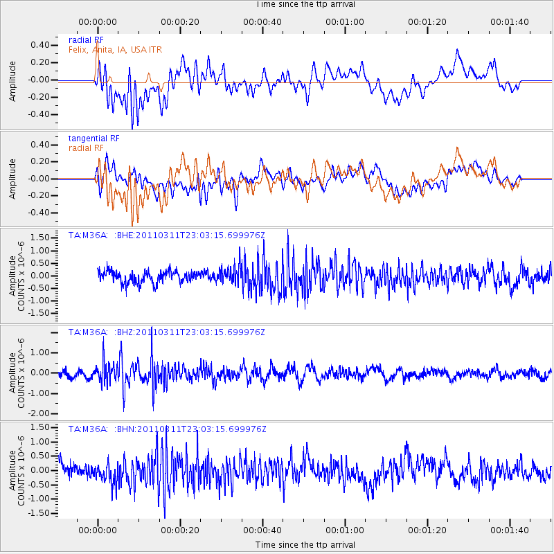
M36A Felix, Anita, IA, USA - Earthquake Result Viewer
*The percent match for this event was below the threshold and hence no stack was calculated.
| Earthquake location: |
Off East Coast Of Honshu, Japan |
| Earthquake latitude/longitude: |
37.8/144.8 |
| Earthquake time(UTC): |
2011/03/11 (070) 22:51:19 GMT |
| Earthquake Depth: |
39 km |
| Earthquake Magnitude: |
5.7 MB |
| Earthquake Catalog/Contributor: |
WHDF/NEIC |
|
| Network: |
TA USArray Transportable Network (new EarthScope stations) |
| Station: |
M36A Felix, Anita, IA, USA |
| Lat/Lon: |
41.45 N/94.80 W |
| Elevation: |
430 m |
|
| Distance: |
84.2 deg |
| Az: |
40.687 deg |
| Baz: |
316.63 deg |
| Ray Param: |
$rayparam |
*The percent match for this event was below the threshold and hence was not used in the summary stack. |
|
| Radial Match: |
61.768112 % |
| Radial Bump: |
400 |
| Transverse Match: |
58.521896 % |
| Transverse Bump: |
400 |
| SOD ConfigId: |
356183 |
| Insert Time: |
2011-08-18 16:53:07.926 +0000 |
| GWidth: |
2.5 |
| Max Bumps: |
400 |
| Tol: |
0.001 |
|
Signal To Noise
| Channel | StoN | STA | LTA |
| TA:M36A: :BHZ:20110311T23:03:15.699976Z | 2.9591875 | 4.952316E-7 | 1.673539E-7 |
| TA:M36A: :BHN:20110311T23:03:15.699976Z | 1.5564991 | 3.7247142E-7 | 2.3930076E-7 |
| TA:M36A: :BHE:20110311T23:03:15.699976Z | 1.4070958 | 3.1708564E-7 | 2.2534758E-7 |
| Arrivals |
| Ps | |
| PpPs | |
| PsPs/PpSs | |


