You are here: Home > Network List > IW - Intermountain West Stations List
> Station IMW Indian Meadow, Wyoming, USA > Earthquake Result Viewer
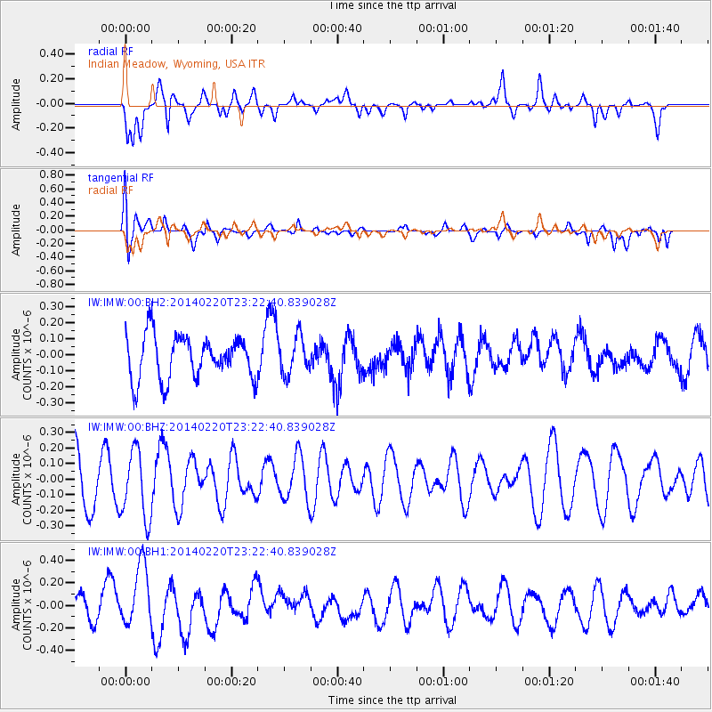
IMW Indian Meadow, Wyoming, USA - Earthquake Result Viewer
*The percent match for this event was below the threshold and hence no stack was calculated.
| Earthquake location: |
Hokkaido, Japan Region |
| Earthquake latitude/longitude: |
45.9/142.6 |
| Earthquake time(UTC): |
2014/02/20 (051) 23:12:38 GMT |
| Earthquake Depth: |
324 km |
| Earthquake Magnitude: |
5.2 MW |
| Earthquake Catalog/Contributor: |
ISC/ISC |
|
| Network: |
IW Intermountain West |
| Station: |
IMW Indian Meadow, Wyoming, USA |
| Lat/Lon: |
43.90 N/110.94 W |
| Elevation: |
2646 m |
|
| Distance: |
69.4 deg |
| Az: |
47.792 deg |
| Baz: |
314.282 deg |
| Ray Param: |
$rayparam |
*The percent match for this event was below the threshold and hence was not used in the summary stack. |
|
| Radial Match: |
50.606335 % |
| Radial Bump: |
400 |
| Transverse Match: |
48.43419 % |
| Transverse Bump: |
400 |
| SOD ConfigId: |
3390531 |
| Insert Time: |
2019-04-10 09:57:25.255 +0000 |
| GWidth: |
2.5 |
| Max Bumps: |
400 |
| Tol: |
0.001 |
|
Signal To Noise
| Channel | StoN | STA | LTA |
| IW:IMW:00:BHZ:20140220T23:22:40.839028Z | 1.1978357 | 2.2103322E-7 | 1.8452717E-7 |
| IW:IMW:00:BH1:20140220T23:22:40.839028Z | 3.1173024 | 2.7359235E-7 | 8.7765734E-8 |
| IW:IMW:00:BH2:20140220T23:22:40.839028Z | 0.8607551 | 1.1654506E-7 | 1.3539864E-7 |
| Arrivals |
| Ps | |
| PpPs | |
| PsPs/PpSs | |


