You are here: Home > Network List > TA - USArray Transportable Network (new EarthScope stations) Stations List
> Station J61A Chester, VT, USA > Earthquake Result Viewer
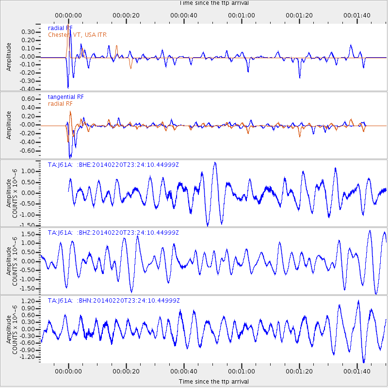
J61A Chester, VT, USA - Earthquake Result Viewer
*The percent match for this event was below the threshold and hence no stack was calculated.
| Earthquake location: |
Hokkaido, Japan Region |
| Earthquake latitude/longitude: |
45.9/142.6 |
| Earthquake time(UTC): |
2014/02/20 (051) 23:12:38 GMT |
| Earthquake Depth: |
324 km |
| Earthquake Magnitude: |
5.2 MW |
| Earthquake Catalog/Contributor: |
ISC/ISC |
|
| Network: |
TA USArray Transportable Network (new EarthScope stations) |
| Station: |
J61A Chester, VT, USA |
| Lat/Lon: |
43.35 N/72.55 W |
| Elevation: |
253 m |
|
| Distance: |
85.8 deg |
| Az: |
24.935 deg |
| Baz: |
336.185 deg |
| Ray Param: |
$rayparam |
*The percent match for this event was below the threshold and hence was not used in the summary stack. |
|
| Radial Match: |
53.310417 % |
| Radial Bump: |
359 |
| Transverse Match: |
78.891304 % |
| Transverse Bump: |
400 |
| SOD ConfigId: |
3390531 |
| Insert Time: |
2019-04-10 09:59:44.032 +0000 |
| GWidth: |
2.5 |
| Max Bumps: |
400 |
| Tol: |
0.001 |
|
Signal To Noise
| Channel | StoN | STA | LTA |
| TA:J61A: :BHZ:20140220T23:24:10.44999Z | 2.5042489 | 8.208498E-7 | 3.2778283E-7 |
| TA:J61A: :BHN:20140220T23:24:10.44999Z | 1.656053 | 3.3410913E-7 | 2.0175027E-7 |
| TA:J61A: :BHE:20140220T23:24:10.44999Z | 1.4360512 | 4.3514387E-7 | 3.0301416E-7 |
| Arrivals |
| Ps | |
| PpPs | |
| PsPs/PpSs | |


