You are here: Home > Network List > TA - USArray Transportable Network (new EarthScope stations) Stations List
> Station P31A Stockton, KS, USA > Earthquake Result Viewer
P31A Stockton, KS, USA - Earthquake Result Viewer
*The percent match for this event was below the threshold and hence no stack was calculated.
| Earthquake location: |
Near East Coast Of Honshu, Japan |
| Earthquake latitude/longitude: |
35.8/141.6 |
| Earthquake time(UTC): |
2011/03/22 (081) 15:03:49 GMT |
| Earthquake Depth: |
35 km |
| Earthquake Magnitude: |
6.0 MB, 5.6 MS, 5.6 MW |
| Earthquake Catalog/Contributor: |
WHDF/NEIC |
|
| Network: |
TA USArray Transportable Network (new EarthScope stations) |
| Station: |
P31A Stockton, KS, USA |
| Lat/Lon: |
39.52 N/99.38 W |
| Elevation: |
665 m |
|
| Distance: |
86.4 deg |
| Az: |
42.641 deg |
| Baz: |
314.603 deg |
| Ray Param: |
$rayparam |
*The percent match for this event was below the threshold and hence was not used in the summary stack. |
|
| Radial Match: |
67.62313 % |
| Radial Bump: |
400 |
| Transverse Match: |
60.796124 % |
| Transverse Bump: |
400 |
| SOD ConfigId: |
356183 |
| Insert Time: |
2011-08-18 18:51:38.696 +0000 |
| GWidth: |
2.5 |
| Max Bumps: |
400 |
| Tol: |
0.001 |
|
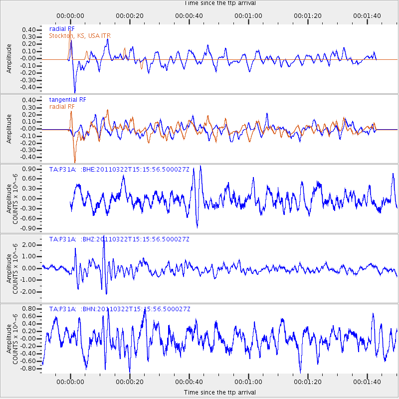
Signal To Noise
| Channel | StoN | STA | LTA |
| TA:P31A: :BHZ:20110322T15:15:56.500027Z | 3.5309663 | 7.5134454E-7 | 2.1278723E-7 |
| TA:P31A: :BHN:20110322T15:15:56.500027Z | 0.97132236 | 2.8148816E-7 | 2.8979892E-7 |
| TA:P31A: :BHE:20110322T15:15:56.500027Z | 0.73905396 | 1.8258343E-7 | 2.4705022E-7 |
| Arrivals |
| Ps | |
| PpPs | |
| PsPs/PpSs | |


