You are here: Home > Network List > UW - Pacific Northwest Regional Seismic Network Stations List
> Station MRBL Marblemount, WA, USA > Earthquake Result Viewer
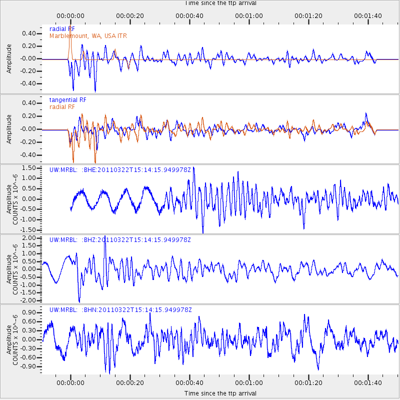
MRBL Marblemount, WA, USA - Earthquake Result Viewer
*The percent match for this event was below the threshold and hence no stack was calculated.
| Earthquake location: |
Near East Coast Of Honshu, Japan |
| Earthquake latitude/longitude: |
35.8/141.6 |
| Earthquake time(UTC): |
2011/03/22 (081) 15:03:49 GMT |
| Earthquake Depth: |
35 km |
| Earthquake Magnitude: |
6.0 MB, 5.6 MS, 5.6 MW |
| Earthquake Catalog/Contributor: |
WHDF/NEIC |
|
| Network: |
UW Pacific Northwest Regional Seismic Network |
| Station: |
MRBL Marblemount, WA, USA |
| Lat/Lon: |
48.52 N/121.48 W |
| Elevation: |
75 m |
|
| Distance: |
68.3 deg |
| Az: |
45.251 deg |
| Baz: |
299.727 deg |
| Ray Param: |
$rayparam |
*The percent match for this event was below the threshold and hence was not used in the summary stack. |
|
| Radial Match: |
76.55273 % |
| Radial Bump: |
400 |
| Transverse Match: |
72.962006 % |
| Transverse Bump: |
400 |
| SOD ConfigId: |
356183 |
| Insert Time: |
2011-08-18 19:52:19.357 +0000 |
| GWidth: |
2.5 |
| Max Bumps: |
400 |
| Tol: |
0.001 |
|
Signal To Noise
| Channel | StoN | STA | LTA |
| UW:MRBL: :BHZ:20110322T15:14:15.949978Z | 1.9256577 | 8.9732305E-7 | 4.6598262E-7 |
| UW:MRBL: :BHN:20110322T15:14:15.949978Z | 0.59097993 | 2.7281268E-7 | 4.6162765E-7 |
| UW:MRBL: :BHE:20110322T15:14:15.949978Z | 1.1894406 | 3.9013145E-7 | 3.2799574E-7 |
| Arrivals |
| Ps | |
| PpPs | |
| PsPs/PpSs | |


