You are here: Home > Network List > TA - USArray Transportable Network (new EarthScope stations) Stations List
> Station 533A Kerrville, TX, USA > Earthquake Result Viewer
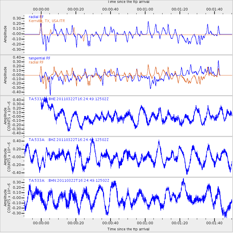
533A Kerrville, TX, USA - Earthquake Result Viewer
*The percent match for this event was below the threshold and hence no stack was calculated.
| Earthquake location: |
Near East Coast Of Honshu, Japan |
| Earthquake latitude/longitude: |
35.7/141.6 |
| Earthquake time(UTC): |
2011/03/22 (081) 16:12:09 GMT |
| Earthquake Depth: |
31 km |
| Earthquake Magnitude: |
5.6 MB, 5.2 MS, 5.3 MW |
| Earthquake Catalog/Contributor: |
WHDF/NEIC |
|
| Network: |
TA USArray Transportable Network (new EarthScope stations) |
| Station: |
533A Kerrville, TX, USA |
| Lat/Lon: |
30.07 N/99.04 W |
| Elevation: |
556 m |
|
| Distance: |
93.2 deg |
| Az: |
49.195 deg |
| Baz: |
314.692 deg |
| Ray Param: |
$rayparam |
*The percent match for this event was below the threshold and hence was not used in the summary stack. |
|
| Radial Match: |
62.40904 % |
| Radial Bump: |
400 |
| Transverse Match: |
54.414497 % |
| Transverse Bump: |
400 |
| SOD ConfigId: |
356183 |
| Insert Time: |
2011-08-18 20:25:09.917 +0000 |
| GWidth: |
2.5 |
| Max Bumps: |
400 |
| Tol: |
0.001 |
|
Signal To Noise
| Channel | StoN | STA | LTA |
| TA:533A: :BHZ:20110322T16:24:49.12502Z | 0.9220696 | 1.6758499E-7 | 1.8174873E-7 |
| TA:533A: :BHN:20110322T16:24:49.12502Z | 1.0116748 | 1.1416895E-7 | 1.1285144E-7 |
| TA:533A: :BHE:20110322T16:24:49.12502Z | 0.5758134 | 1.1794598E-7 | 2.0483367E-7 |
| Arrivals |
| Ps | |
| PpPs | |
| PsPs/PpSs | |


