You are here: Home > Network List > TA - USArray Transportable Network (new EarthScope stations) Stations List
> Station K31A O'Neill, NE, USA > Earthquake Result Viewer
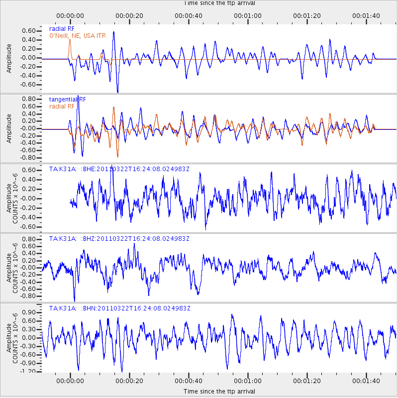
K31A O'Neill, NE, USA - Earthquake Result Viewer
*The percent match for this event was below the threshold and hence no stack was calculated.
| Earthquake location: |
Near East Coast Of Honshu, Japan |
| Earthquake latitude/longitude: |
35.7/141.6 |
| Earthquake time(UTC): |
2011/03/22 (081) 16:12:09 GMT |
| Earthquake Depth: |
31 km |
| Earthquake Magnitude: |
5.6 MB, 5.2 MS, 5.3 MW |
| Earthquake Catalog/Contributor: |
WHDF/NEIC |
|
| Network: |
TA USArray Transportable Network (new EarthScope stations) |
| Station: |
K31A O'Neill, NE, USA |
| Lat/Lon: |
42.62 N/98.75 W |
| Elevation: |
580 m |
|
| Distance: |
84.6 deg |
| Az: |
40.137 deg |
| Baz: |
314.681 deg |
| Ray Param: |
$rayparam |
*The percent match for this event was below the threshold and hence was not used in the summary stack. |
|
| Radial Match: |
53.17811 % |
| Radial Bump: |
400 |
| Transverse Match: |
65.28618 % |
| Transverse Bump: |
400 |
| SOD ConfigId: |
356183 |
| Insert Time: |
2011-08-18 20:30:44.184 +0000 |
| GWidth: |
2.5 |
| Max Bumps: |
400 |
| Tol: |
0.001 |
|
Signal To Noise
| Channel | StoN | STA | LTA |
| TA:K31A: :BHZ:20110322T16:24:08.024983Z | 3.0582926 | 3.358323E-7 | 1.09810394E-7 |
| TA:K31A: :BHN:20110322T16:24:08.024983Z | 1.5732979 | 4.2993992E-7 | 2.7327306E-7 |
| TA:K31A: :BHE:20110322T16:24:08.024983Z | 0.9878271 | 2.2655183E-7 | 2.2934361E-7 |
| Arrivals |
| Ps | |
| PpPs | |
| PsPs/PpSs | |


