You are here: Home > Network List > TA - USArray Transportable Network (new EarthScope stations) Stations List
> Station P39A Salisbury, MO, USA > Earthquake Result Viewer
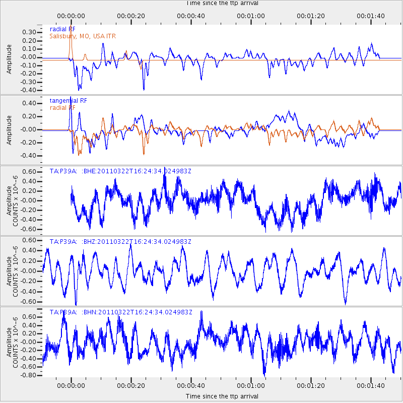
P39A Salisbury, MO, USA - Earthquake Result Viewer
*The percent match for this event was below the threshold and hence no stack was calculated.
| Earthquake location: |
Near East Coast Of Honshu, Japan |
| Earthquake latitude/longitude: |
35.7/141.6 |
| Earthquake time(UTC): |
2011/03/22 (081) 16:12:09 GMT |
| Earthquake Depth: |
31 km |
| Earthquake Magnitude: |
5.6 MB, 5.2 MS, 5.3 MW |
| Earthquake Catalog/Contributor: |
WHDF/NEIC |
|
| Network: |
TA USArray Transportable Network (new EarthScope stations) |
| Station: |
P39A Salisbury, MO, USA |
| Lat/Lon: |
39.49 N/92.75 W |
| Elevation: |
232 m |
|
| Distance: |
89.9 deg |
| Az: |
38.988 deg |
| Baz: |
318.555 deg |
| Ray Param: |
$rayparam |
*The percent match for this event was below the threshold and hence was not used in the summary stack. |
|
| Radial Match: |
38.71831 % |
| Radial Bump: |
400 |
| Transverse Match: |
53.50281 % |
| Transverse Bump: |
400 |
| SOD ConfigId: |
356183 |
| Insert Time: |
2011-08-18 20:35:32.470 +0000 |
| GWidth: |
2.5 |
| Max Bumps: |
400 |
| Tol: |
0.001 |
|
Signal To Noise
| Channel | StoN | STA | LTA |
| TA:P39A: :BHZ:20110322T16:24:34.024983Z | 1.0197985 | 2.6926514E-7 | 2.640376E-7 |
| TA:P39A: :BHN:20110322T16:24:34.024983Z | 0.865797 | 2.3049378E-7 | 2.662215E-7 |
| TA:P39A: :BHE:20110322T16:24:34.024983Z | 1.1369959 | 2.6560306E-7 | 2.3360073E-7 |
| Arrivals |
| Ps | |
| PpPs | |
| PsPs/PpSs | |


