You are here: Home > Network List > CI - Caltech Regional Seismic Network Stations List
> Station BAR Barrett, Tecate, CA, USA > Earthquake Result Viewer
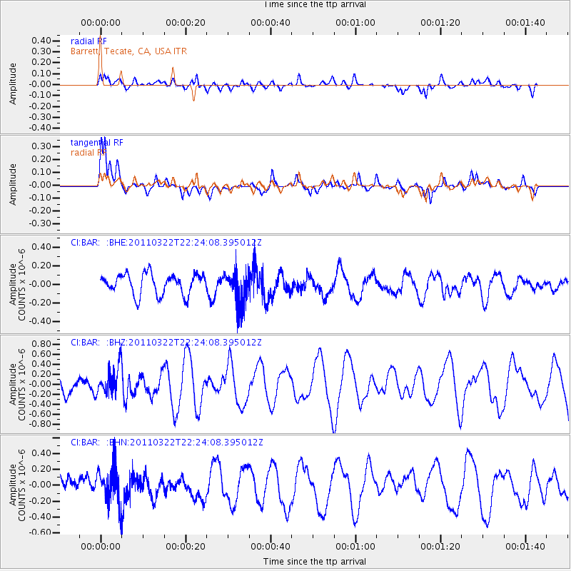
BAR Barrett, Tecate, CA, USA - Earthquake Result Viewer
*The percent match for this event was below the threshold and hence no stack was calculated.
| Earthquake location: |
Eastern Honshu, Japan |
| Earthquake latitude/longitude: |
37.1/140.6 |
| Earthquake time(UTC): |
2011/03/22 (081) 22:12:31 GMT |
| Earthquake Depth: |
18 km |
| Earthquake Magnitude: |
5.5 MB, 5.4 MS, 5.7 MW, 5.5 MW |
| Earthquake Catalog/Contributor: |
WHDF/NEIC |
|
| Network: |
CI Caltech Regional Seismic Network |
| Station: |
BAR Barrett, Tecate, CA, USA |
| Lat/Lon: |
32.68 N/116.67 W |
| Elevation: |
521 m |
|
| Distance: |
80.0 deg |
| Az: |
56.671 deg |
| Baz: |
307.581 deg |
| Ray Param: |
$rayparam |
*The percent match for this event was below the threshold and hence was not used in the summary stack. |
|
| Radial Match: |
57.61839 % |
| Radial Bump: |
400 |
| Transverse Match: |
80.08841 % |
| Transverse Bump: |
400 |
| SOD ConfigId: |
356183 |
| Insert Time: |
2011-08-18 20:52:42.236 +0000 |
| GWidth: |
2.5 |
| Max Bumps: |
400 |
| Tol: |
0.001 |
|
Signal To Noise
| Channel | StoN | STA | LTA |
| CI:BAR: :BHZ:20110322T22:24:08.395012Z | 1.0350004 | 2.7444665E-7 | 2.6516577E-7 |
| CI:BAR: :BHN:20110322T22:24:08.395012Z | 1.6114504 | 2.2237089E-7 | 1.3799423E-7 |
| CI:BAR: :BHE:20110322T22:24:08.395012Z | 1.542475 | 1.7212336E-7 | 1.1158908E-7 |
| Arrivals |
| Ps | |
| PpPs | |
| PsPs/PpSs | |


