You are here: Home > Network List > TA - USArray Transportable Network (new EarthScope stations) Stations List
> Station H25A Fruitdale, SD, USA > Earthquake Result Viewer
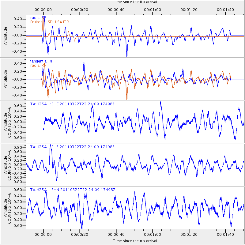
H25A Fruitdale, SD, USA - Earthquake Result Viewer
*The percent match for this event was below the threshold and hence no stack was calculated.
| Earthquake location: |
Eastern Honshu, Japan |
| Earthquake latitude/longitude: |
37.1/140.6 |
| Earthquake time(UTC): |
2011/03/22 (081) 22:12:31 GMT |
| Earthquake Depth: |
18 km |
| Earthquake Magnitude: |
5.5 MB, 5.4 MS, 5.7 MW, 5.5 MW |
| Earthquake Catalog/Contributor: |
WHDF/NEIC |
|
| Network: |
TA USArray Transportable Network (new EarthScope stations) |
| Station: |
H25A Fruitdale, SD, USA |
| Lat/Lon: |
44.62 N/103.60 W |
| Elevation: |
942 m |
|
| Distance: |
80.1 deg |
| Az: |
40.756 deg |
| Baz: |
313.008 deg |
| Ray Param: |
$rayparam |
*The percent match for this event was below the threshold and hence was not used in the summary stack. |
|
| Radial Match: |
60.438023 % |
| Radial Bump: |
400 |
| Transverse Match: |
56.827663 % |
| Transverse Bump: |
400 |
| SOD ConfigId: |
356183 |
| Insert Time: |
2011-08-18 21:19:08.376 +0000 |
| GWidth: |
2.5 |
| Max Bumps: |
400 |
| Tol: |
0.001 |
|
Signal To Noise
| Channel | StoN | STA | LTA |
| TA:H25A: :BHZ:20110322T22:24:09.17498Z | 3.2928472 | 4.2011706E-7 | 1.2758474E-7 |
| TA:H25A: :BHN:20110322T22:24:09.17498Z | 1.0793377 | 2.7156185E-7 | 2.5160043E-7 |
| TA:H25A: :BHE:20110322T22:24:09.17498Z | 0.8503958 | 1.4625839E-7 | 1.719886E-7 |
| Arrivals |
| Ps | |
| PpPs | |
| PsPs/PpSs | |


