You are here: Home > Network List > US - United States National Seismic Network Stations List
> Station AMTX Amarillo, Texas, USA > Earthquake Result Viewer
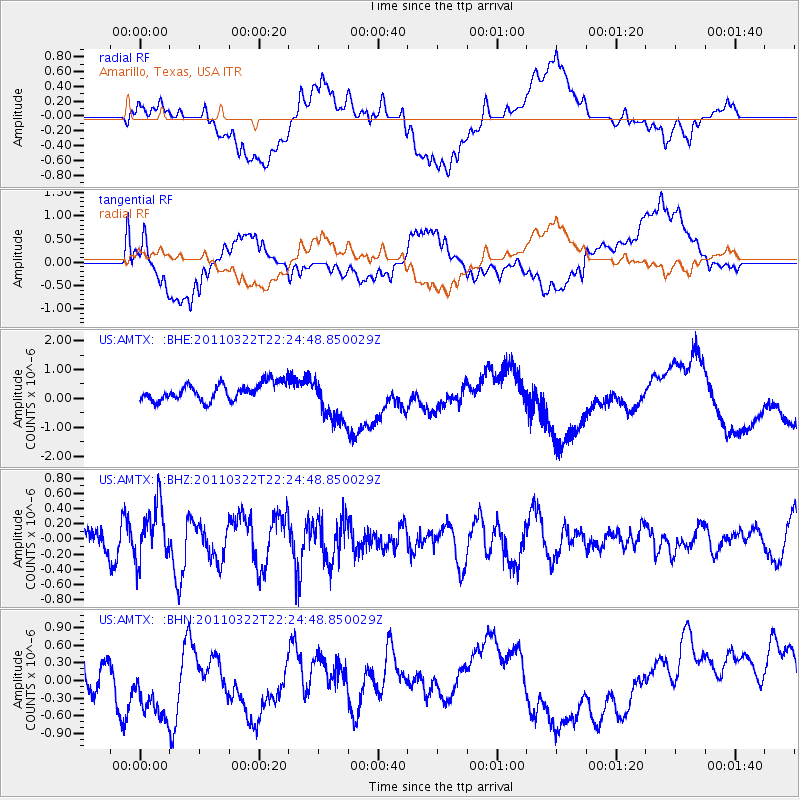
AMTX Amarillo, Texas, USA - Earthquake Result Viewer
*The percent match for this event was below the threshold and hence no stack was calculated.
| Earthquake location: |
Eastern Honshu, Japan |
| Earthquake latitude/longitude: |
37.1/140.6 |
| Earthquake time(UTC): |
2011/03/22 (081) 22:12:31 GMT |
| Earthquake Depth: |
18 km |
| Earthquake Magnitude: |
5.5 MB, 5.4 MS, 5.7 MW, 5.5 MW |
| Earthquake Catalog/Contributor: |
WHDF/NEIC |
|
| Network: |
US United States National Seismic Network |
| Station: |
AMTX Amarillo, Texas, USA |
| Lat/Lon: |
34.53 N/101.41 W |
| Elevation: |
1010 m |
|
| Distance: |
88.3 deg |
| Az: |
46.852 deg |
| Baz: |
315.019 deg |
| Ray Param: |
$rayparam |
*The percent match for this event was below the threshold and hence was not used in the summary stack. |
|
| Radial Match: |
49.865574 % |
| Radial Bump: |
400 |
| Transverse Match: |
48.18691 % |
| Transverse Bump: |
400 |
| SOD ConfigId: |
356183 |
| Insert Time: |
2011-08-18 21:55:59.712 +0000 |
| GWidth: |
2.5 |
| Max Bumps: |
400 |
| Tol: |
0.001 |
|
Signal To Noise
| Channel | StoN | STA | LTA |
| US:AMTX: :BHZ:20110322T22:24:48.850029Z | 3.0466812 | 3.6750595E-7 | 1.2062502E-7 |
| US:AMTX: :BHN:20110322T22:24:48.850029Z | 1.9350574 | 7.0795653E-7 | 3.6585814E-7 |
| US:AMTX: :BHE:20110322T22:24:48.850029Z | 3.8731472 | 1.216868E-6 | 3.1418068E-7 |
| Arrivals |
| Ps | |
| PpPs | |
| PsPs/PpSs | |


