You are here: Home > Network List > KN - Kyrgyz Seismic Telemetry Network Stations List
> Station TKM2 KN.TKM2 > Earthquake Result Viewer
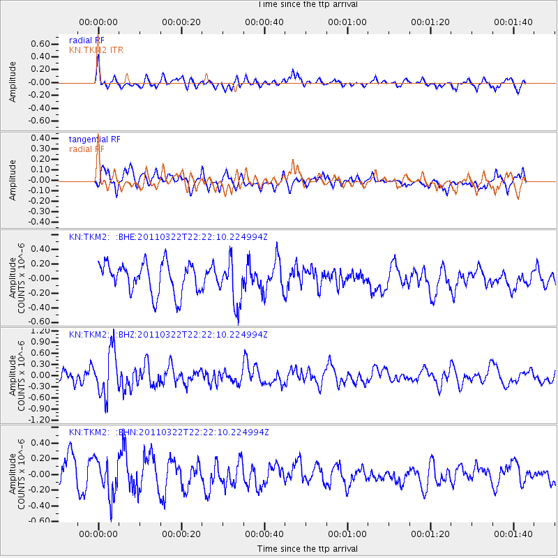
TKM2 KN.TKM2 - Earthquake Result Viewer
*The percent match for this event was below the threshold and hence no stack was calculated.
| Earthquake location: |
Eastern Honshu, Japan |
| Earthquake latitude/longitude: |
37.0/140.7 |
| Earthquake time(UTC): |
2011/03/22 (081) 22:13:57 GMT |
| Earthquake Depth: |
41 km |
| Earthquake Magnitude: |
5.5 MB, 5.3 MS |
| Earthquake Catalog/Contributor: |
WHDF/NEIC |
|
| Network: |
KN Kyrgyz Seismic Telemetry Network |
| Station: |
TKM2 KN.TKM2 |
| Lat/Lon: |
42.92 N/75.60 E |
| Elevation: |
2020 m |
|
| Distance: |
49.1 deg |
| Az: |
298.226 deg |
| Baz: |
73.756 deg |
| Ray Param: |
$rayparam |
*The percent match for this event was below the threshold and hence was not used in the summary stack. |
|
| Radial Match: |
49.013264 % |
| Radial Bump: |
400 |
| Transverse Match: |
56.8013 % |
| Transverse Bump: |
400 |
| SOD ConfigId: |
356183 |
| Insert Time: |
2011-08-18 22:15:36.546 +0000 |
| GWidth: |
2.5 |
| Max Bumps: |
400 |
| Tol: |
0.001 |
|
Signal To Noise
| Channel | StoN | STA | LTA |
| KN:TKM2: :BHZ:20110322T22:22:10.224994Z | 3.9234073 | 6.2000476E-7 | 1.5802713E-7 |
| KN:TKM2: :BHN:20110322T22:22:10.224994Z | 1.1381361 | 2.3162241E-7 | 2.0351027E-7 |
| KN:TKM2: :BHE:20110322T22:22:10.224994Z | 1.4575597 | 3.0168852E-7 | 2.0698192E-7 |
| Arrivals |
| Ps | |
| PpPs | |
| PsPs/PpSs | |


