You are here: Home > Network List > IU - Global Seismograph Network (GSN - IRIS/USGS) Stations List
> Station FURI Mt. Furi, Ethiopia > Earthquake Result Viewer
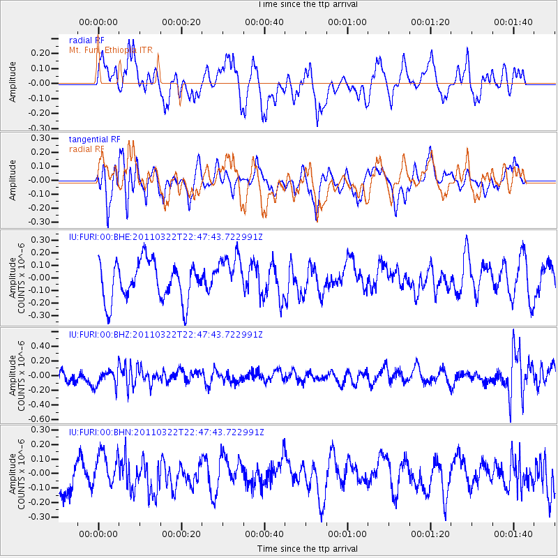
FURI Mt. Furi, Ethiopia - Earthquake Result Viewer
*The percent match for this event was below the threshold and hence no stack was calculated.
| Earthquake location: |
Eastern Honshu, Japan |
| Earthquake latitude/longitude: |
37.1/140.6 |
| Earthquake time(UTC): |
2011/03/22 (081) 22:35:00 GMT |
| Earthquake Depth: |
38 km |
| Earthquake Magnitude: |
5.5 MB |
| Earthquake Catalog/Contributor: |
WHDF/NEIC |
|
| Network: |
IU Global Seismograph Network (GSN - IRIS/USGS) |
| Station: |
FURI Mt. Furi, Ethiopia |
| Lat/Lon: |
8.90 N/38.68 E |
| Elevation: |
2570 m |
|
| Distance: |
94.0 deg |
| Az: |
284.231 deg |
| Baz: |
51.646 deg |
| Ray Param: |
$rayparam |
*The percent match for this event was below the threshold and hence was not used in the summary stack. |
|
| Radial Match: |
53.01241 % |
| Radial Bump: |
400 |
| Transverse Match: |
51.402493 % |
| Transverse Bump: |
348 |
| SOD ConfigId: |
356183 |
| Insert Time: |
2011-08-18 22:59:29.666 +0000 |
| GWidth: |
2.5 |
| Max Bumps: |
400 |
| Tol: |
0.001 |
|
Signal To Noise
| Channel | StoN | STA | LTA |
| IU:FURI:00:BHZ:20110322T22:47:43.722991Z | 1.3982035 | 1.1331923E-7 | 8.104631E-8 |
| IU:FURI:00:BHN:20110322T22:47:43.722991Z | 1.0823942 | 1.2307738E-7 | 1.1370847E-7 |
| IU:FURI:00:BHE:20110322T22:47:43.722991Z | 1.107211 | 1.6890748E-7 | 1.525522E-7 |
| Arrivals |
| Ps | |
| PpPs | |
| PsPs/PpSs | |


