You are here: Home > Network List > TA - USArray Transportable Network (new EarthScope stations) Stations List
> Station P30A Selden, KS, USA > Earthquake Result Viewer
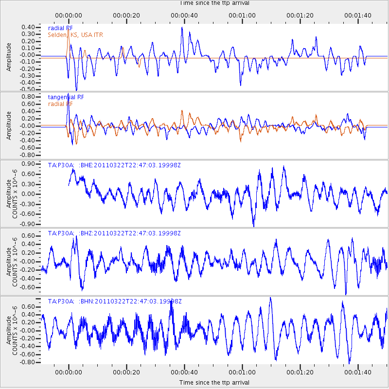
P30A Selden, KS, USA - Earthquake Result Viewer
*The percent match for this event was below the threshold and hence no stack was calculated.
| Earthquake location: |
Eastern Honshu, Japan |
| Earthquake latitude/longitude: |
37.1/140.6 |
| Earthquake time(UTC): |
2011/03/22 (081) 22:35:00 GMT |
| Earthquake Depth: |
38 km |
| Earthquake Magnitude: |
5.5 MB |
| Earthquake Catalog/Contributor: |
WHDF/NEIC |
|
| Network: |
TA USArray Transportable Network (new EarthScope stations) |
| Station: |
P30A Selden, KS, USA |
| Lat/Lon: |
39.54 N/100.25 W |
| Elevation: |
788 m |
|
| Distance: |
85.4 deg |
| Az: |
42.633 deg |
| Baz: |
315.554 deg |
| Ray Param: |
$rayparam |
*The percent match for this event was below the threshold and hence was not used in the summary stack. |
|
| Radial Match: |
49.773636 % |
| Radial Bump: |
400 |
| Transverse Match: |
47.69111 % |
| Transverse Bump: |
400 |
| SOD ConfigId: |
356183 |
| Insert Time: |
2011-08-18 23:07:04.938 +0000 |
| GWidth: |
2.5 |
| Max Bumps: |
400 |
| Tol: |
0.001 |
|
Signal To Noise
| Channel | StoN | STA | LTA |
| TA:P30A: :BHZ:20110322T22:47:03.19998Z | 2.247009 | 3.4542356E-7 | 1.5372594E-7 |
| TA:P30A: :BHN:20110322T22:47:03.19998Z | 0.87755585 | 2.3306495E-7 | 2.655842E-7 |
| TA:P30A: :BHE:20110322T22:47:03.19998Z | 1.2104738 | 3.1644663E-7 | 2.6142376E-7 |
| Arrivals |
| Ps | |
| PpPs | |
| PsPs/PpSs | |


