You are here: Home > Network List > TA - USArray Transportable Network (new EarthScope stations) Stations List
> Station R11A Troy Canyon, Currant, NV, USA > Earthquake Result Viewer
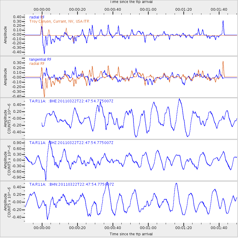
R11A Troy Canyon, Currant, NV, USA - Earthquake Result Viewer
*The percent match for this event was below the threshold and hence no stack was calculated.
| Earthquake location: |
Eastern Honshu, Japan |
| Earthquake latitude/longitude: |
37.1/140.6 |
| Earthquake time(UTC): |
2011/03/22 (081) 22:36:32 GMT |
| Earthquake Depth: |
16 km |
| Earthquake Magnitude: |
5.5 MB, 5.2 MS, 5.4 MW, 5.2 MW |
| Earthquake Catalog/Contributor: |
WHDF/NEIC |
|
| Network: |
TA USArray Transportable Network (new EarthScope stations) |
| Station: |
R11A Troy Canyon, Currant, NV, USA |
| Lat/Lon: |
38.35 N/115.59 W |
| Elevation: |
1756 m |
|
| Distance: |
77.3 deg |
| Az: |
51.504 deg |
| Baz: |
307.266 deg |
| Ray Param: |
$rayparam |
*The percent match for this event was below the threshold and hence was not used in the summary stack. |
|
| Radial Match: |
63.554165 % |
| Radial Bump: |
400 |
| Transverse Match: |
59.742355 % |
| Transverse Bump: |
400 |
| SOD ConfigId: |
356183 |
| Insert Time: |
2011-08-18 23:42:48.739 +0000 |
| GWidth: |
2.5 |
| Max Bumps: |
400 |
| Tol: |
0.001 |
|
Signal To Noise
| Channel | StoN | STA | LTA |
| TA:R11A: :BHZ:20110322T22:47:54.775007Z | 3.1588814 | 6.2102686E-7 | 1.9659707E-7 |
| TA:R11A: :BHN:20110322T22:47:54.775007Z | 0.91288555 | 1.8624985E-7 | 2.0402322E-7 |
| TA:R11A: :BHE:20110322T22:47:54.775007Z | 2.1759095 | 3.0773168E-7 | 1.414267E-7 |
| Arrivals |
| Ps | |
| PpPs | |
| PsPs/PpSs | |


