You are here: Home > Network List > TA - USArray Transportable Network (new EarthScope stations) Stations List
> Station MSTX Muleshoe, TX, USA > Earthquake Result Viewer
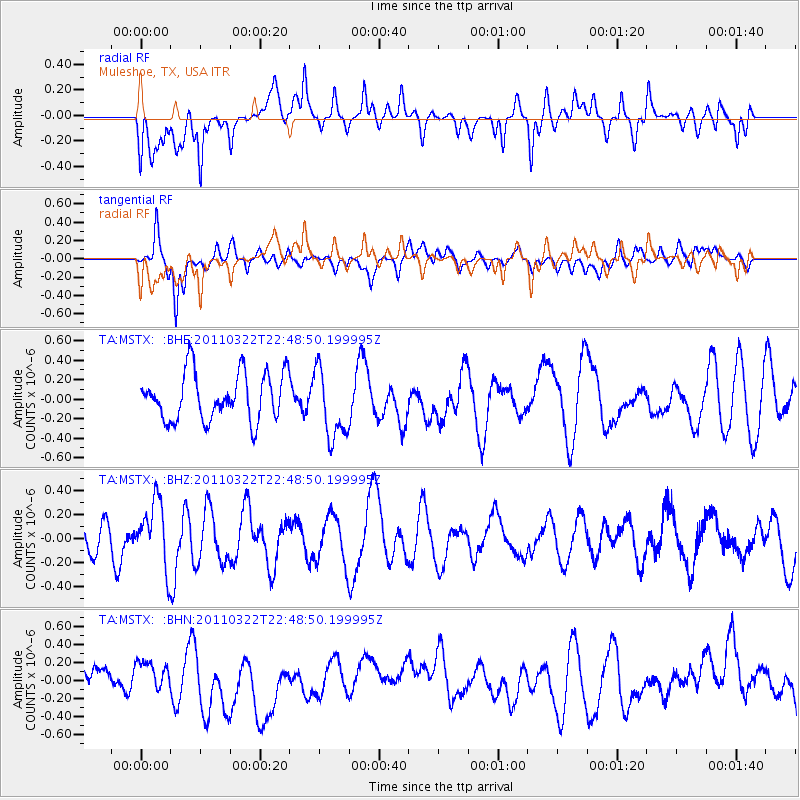
MSTX Muleshoe, TX, USA - Earthquake Result Viewer
*The percent match for this event was below the threshold and hence no stack was calculated.
| Earthquake location: |
Eastern Honshu, Japan |
| Earthquake latitude/longitude: |
37.1/140.6 |
| Earthquake time(UTC): |
2011/03/22 (081) 22:36:32 GMT |
| Earthquake Depth: |
16 km |
| Earthquake Magnitude: |
5.5 MB, 5.2 MS, 5.4 MW, 5.2 MW |
| Earthquake Catalog/Contributor: |
WHDF/NEIC |
|
| Network: |
TA USArray Transportable Network (new EarthScope stations) |
| Station: |
MSTX Muleshoe, TX, USA |
| Lat/Lon: |
33.97 N/102.77 W |
| Elevation: |
1167 m |
|
| Distance: |
87.9 deg |
| Az: |
47.997 deg |
| Baz: |
314.365 deg |
| Ray Param: |
$rayparam |
*The percent match for this event was below the threshold and hence was not used in the summary stack. |
|
| Radial Match: |
60.496834 % |
| Radial Bump: |
400 |
| Transverse Match: |
64.19045 % |
| Transverse Bump: |
400 |
| SOD ConfigId: |
356183 |
| Insert Time: |
2011-08-18 23:42:54.103 +0000 |
| GWidth: |
2.5 |
| Max Bumps: |
400 |
| Tol: |
0.001 |
|
Signal To Noise
| Channel | StoN | STA | LTA |
| TA:MSTX: :BHZ:20110322T22:48:50.199995Z | 1.9302721 | 2.7028196E-7 | 1.4002272E-7 |
| TA:MSTX: :BHN:20110322T22:48:50.199995Z | 0.62626237 | 1.5658657E-7 | 2.5003348E-7 |
| TA:MSTX: :BHE:20110322T22:48:50.199995Z | 1.4874614 | 3.6269495E-7 | 2.4383485E-7 |
| Arrivals |
| Ps | |
| PpPs | |
| PsPs/PpSs | |


