You are here: Home > Network List > CI - Caltech Regional Seismic Network Stations List
> Station LGU Laguna Peak, California, USA > Earthquake Result Viewer
LGU Laguna Peak, California, USA - Earthquake Result Viewer
| Earthquake location: |
Off Coast Of Costa Rica |
| Earthquake latitude/longitude: |
9.4/-85.3 |
| Earthquake time(UTC): |
2000/07/21 (203) 01:53:35 GMT |
| Earthquake Depth: |
33 km |
| Earthquake Magnitude: |
5.9 MB, 6.1 MS, 6.4 MW, 5.7 ML |
| Earthquake Catalog/Contributor: |
WHDF/NEIC |
|
| Network: |
CI Caltech Regional Seismic Network |
| Station: |
LGU Laguna Peak, California, USA |
| Lat/Lon: |
34.11 N/119.07 W |
| Elevation: |
381 m |
|
| Distance: |
39.5 deg |
| Az: |
313.586 deg |
| Baz: |
120.527 deg |
| Ray Param: |
0.074881025 |
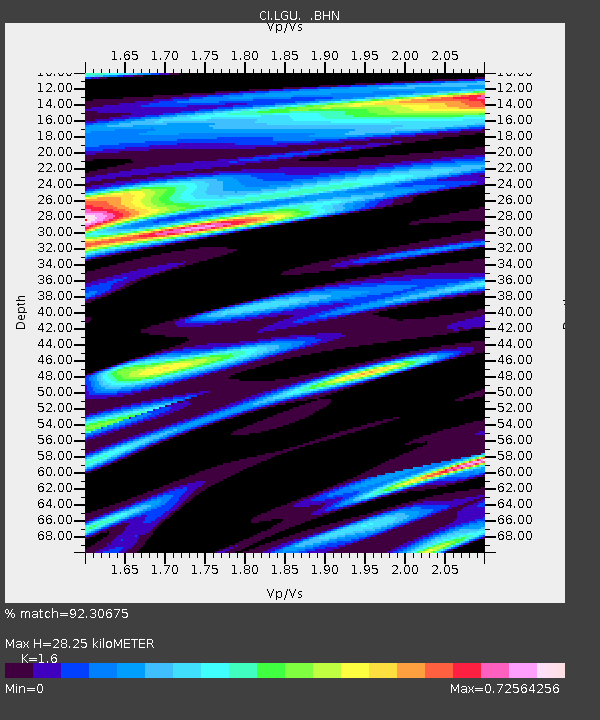
| Estimated Moho Depth: |
28.25 km |
| Estimated Crust Vp/Vs: |
1.60 |
| Assumed Crust Vp: |
6.1 km/s |
| Estimated Crust Vs: |
3.812 km/s |
| Estimated Crust Poisson's Ratio: |
0.18 |
|
| Radial Match: |
92.30675 % |
| Radial Bump: |
360 |
| Transverse Match: |
85.1126 % |
| Transverse Bump: |
400 |
| SOD ConfigId: |
3744 |
| Insert Time: |
2010-02-25 20:13:57.138 +0000 |
| GWidth: |
2.5 |
| Max Bumps: |
400 |
| Tol: |
0.001 |
|
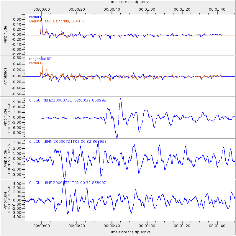
Signal To Noise
| Channel | StoN | STA | LTA |
| CI:LGU: :BHN:20000721T02:00:32.86899Z | 0.9966269 | 2.3944907E-7 | 2.4025948E-7 |
| CI:LGU: :BHE:20000721T02:00:32.86899Z | 1.0646397 | 3.346055E-7 | 3.1428988E-7 |
| CI:LGU: :BHZ:20000721T02:00:32.86899Z | 1.429244 | 3.337977E-7 | 2.3354842E-7 |
| Arrivals |
| Ps | 3.0 SECOND |
| PpPs | 11 SECOND |
| PsPs/PpSs | 14 SECOND |


