You are here: Home > Network List > XL12 - Hangay Dome, Mongolia Stations List
> Station HD11 HD11 > Earthquake Result Viewer
HD11 HD11 - Earthquake Result Viewer
| Earthquake location: |
Northern Sumatra, Indonesia |
| Earthquake latitude/longitude: |
1.2/97.3 |
| Earthquake time(UTC): |
2014/02/22 (053) 17:29:51 GMT |
| Earthquake Depth: |
29 km |
| Earthquake Magnitude: |
5.4 MW |
| Earthquake Catalog/Contributor: |
ISC/ISC |
|
| Network: |
XL Hangay Dome, Mongolia |
| Station: |
HD11 HD11 |
| Lat/Lon: |
46.59 N/100.91 E |
| Elevation: |
2233 m |
|
| Distance: |
45.3 deg |
| Az: |
3.518 deg |
| Baz: |
185.103 deg |
| Ray Param: |
0.07128877 |
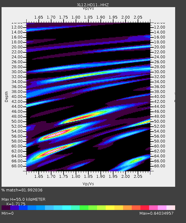
| Estimated Moho Depth: |
55.0 km |
| Estimated Crust Vp/Vs: |
1.72 |
| Assumed Crust Vp: |
6.642 km/s |
| Estimated Crust Vs: |
3.867 km/s |
| Estimated Crust Poisson's Ratio: |
0.24 |
|
| Radial Match: |
81.992836 % |
| Radial Bump: |
400 |
| Transverse Match: |
63.293667 % |
| Transverse Bump: |
400 |
| SOD ConfigId: |
3390531 |
| Insert Time: |
2019-04-10 10:13:21.671 +0000 |
| GWidth: |
2.5 |
| Max Bumps: |
400 |
| Tol: |
0.001 |
|

Signal To Noise
| Channel | StoN | STA | LTA |
| XL:HD11: :HHZ:20140222T17:37:36.04899Z | 8.993594 | 4.0300034E-7 | 4.480971E-8 |
| XL:HD11: :HHN:20140222T17:37:36.04899Z | 6.4620667 | 2.0297311E-7 | 3.1409936E-8 |
| XL:HD11: :HHE:20140222T17:37:36.04899Z | 1.3772559 | 4.3311463E-8 | 3.1447648E-8 |
| Arrivals |
| Ps | 6.4 SECOND |
| PpPs | 21 SECOND |
| PsPs/PpSs | 27 SECOND |


