You are here: Home > Network List > TA - USArray Transportable Network (new EarthScope stations) Stations List
> Station H34A Spellman Lake, Hanley Falls, MN, USA > Earthquake Result Viewer
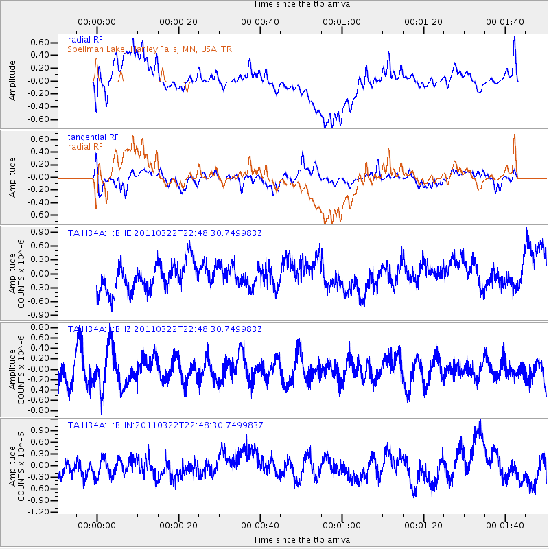
H34A Spellman Lake, Hanley Falls, MN, USA - Earthquake Result Viewer
*The percent match for this event was below the threshold and hence no stack was calculated.
| Earthquake location: |
Eastern Honshu, Japan |
| Earthquake latitude/longitude: |
37.1/140.6 |
| Earthquake time(UTC): |
2011/03/22 (081) 22:36:32 GMT |
| Earthquake Depth: |
16 km |
| Earthquake Magnitude: |
5.5 MB, 5.2 MS, 5.4 MW, 5.2 MW |
| Earthquake Catalog/Contributor: |
WHDF/NEIC |
|
| Network: |
TA USArray Transportable Network (new EarthScope stations) |
| Station: |
H34A Spellman Lake, Hanley Falls, MN, USA |
| Lat/Lon: |
44.67 N/95.78 W |
| Elevation: |
329 m |
|
| Distance: |
84.0 deg |
| Az: |
36.665 deg |
| Baz: |
318.004 deg |
| Ray Param: |
$rayparam |
*The percent match for this event was below the threshold and hence was not used in the summary stack. |
|
| Radial Match: |
57.291653 % |
| Radial Bump: |
400 |
| Transverse Match: |
62.699127 % |
| Transverse Bump: |
400 |
| SOD ConfigId: |
356183 |
| Insert Time: |
2011-08-18 23:57:37.520 +0000 |
| GWidth: |
2.5 |
| Max Bumps: |
400 |
| Tol: |
0.001 |
|
Signal To Noise
| Channel | StoN | STA | LTA |
| TA:H34A: :BHZ:20110322T22:48:30.749983Z | 1.5979807 | 4.1603772E-7 | 2.6035215E-7 |
| TA:H34A: :BHN:20110322T22:48:30.749983Z | 1.135775 | 3.1702282E-7 | 2.7912466E-7 |
| TA:H34A: :BHE:20110322T22:48:30.749983Z | 0.77739584 | 2.3484036E-7 | 3.0208597E-7 |
| Arrivals |
| Ps | |
| PpPs | |
| PsPs/PpSs | |


