You are here: Home > Network List > TA - USArray Transportable Network (new EarthScope stations) Stations List
> Station G32A Webster, SD, USA > Earthquake Result Viewer
G32A Webster, SD, USA - Earthquake Result Viewer
*The percent match for this event was below the threshold and hence no stack was calculated.
| Earthquake location: |
Eastern Honshu, Japan |
| Earthquake latitude/longitude: |
37.1/140.6 |
| Earthquake time(UTC): |
2011/03/22 (081) 22:36:32 GMT |
| Earthquake Depth: |
16 km |
| Earthquake Magnitude: |
5.5 MB, 5.2 MS, 5.4 MW, 5.2 MW |
| Earthquake Catalog/Contributor: |
WHDF/NEIC |
|
| Network: |
TA USArray Transportable Network (new EarthScope stations) |
| Station: |
G32A Webster, SD, USA |
| Lat/Lon: |
45.26 N/97.50 W |
| Elevation: |
566 m |
|
| Distance: |
82.7 deg |
| Az: |
37.171 deg |
| Baz: |
316.85 deg |
| Ray Param: |
$rayparam |
*The percent match for this event was below the threshold and hence was not used in the summary stack. |
|
| Radial Match: |
54.636574 % |
| Radial Bump: |
400 |
| Transverse Match: |
48.60148 % |
| Transverse Bump: |
400 |
| SOD ConfigId: |
356183 |
| Insert Time: |
2011-08-18 23:59:48.912 +0000 |
| GWidth: |
2.5 |
| Max Bumps: |
400 |
| Tol: |
0.001 |
|
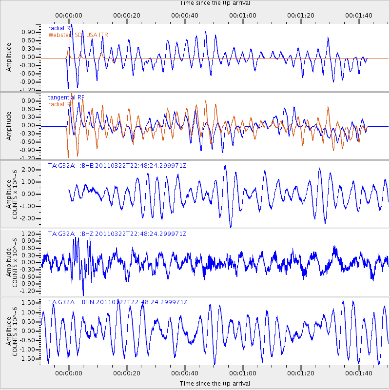
Signal To Noise
| Channel | StoN | STA | LTA |
| TA:G32A: :BHZ:20110322T22:48:24.299971Z | 2.6510048 | 5.26366E-7 | 1.9855341E-7 |
| TA:G32A: :BHN:20110322T22:48:24.299971Z | 1.1916018 | 7.829575E-7 | 6.57063E-7 |
| TA:G32A: :BHE:20110322T22:48:24.299971Z | 2.0823088 | 1.147494E-6 | 5.510681E-7 |
| Arrivals |
| Ps | |
| PpPs | |
| PsPs/PpSs | |


