You are here: Home > Network List > TA - USArray Transportable Network (new EarthScope stations) Stations List
> Station L37A Phoenix Point, Boone, IA, USA > Earthquake Result Viewer
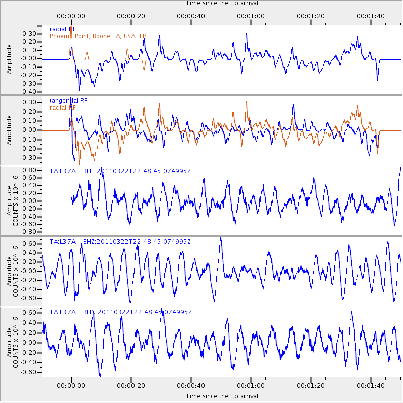
L37A Phoenix Point, Boone, IA, USA - Earthquake Result Viewer
*The percent match for this event was below the threshold and hence no stack was calculated.
| Earthquake location: |
Eastern Honshu, Japan |
| Earthquake latitude/longitude: |
37.1/140.6 |
| Earthquake time(UTC): |
2011/03/22 (081) 22:36:32 GMT |
| Earthquake Depth: |
16 km |
| Earthquake Magnitude: |
5.5 MB, 5.2 MS, 5.4 MW, 5.2 MW |
| Earthquake Catalog/Contributor: |
WHDF/NEIC |
|
| Network: |
TA USArray Transportable Network (new EarthScope stations) |
| Station: |
L37A Phoenix Point, Boone, IA, USA |
| Lat/Lon: |
42.12 N/93.75 W |
| Elevation: |
312 m |
|
| Distance: |
86.9 deg |
| Az: |
37.236 deg |
| Baz: |
319.435 deg |
| Ray Param: |
$rayparam |
*The percent match for this event was below the threshold and hence was not used in the summary stack. |
|
| Radial Match: |
57.21197 % |
| Radial Bump: |
400 |
| Transverse Match: |
60.852142 % |
| Transverse Bump: |
400 |
| SOD ConfigId: |
356183 |
| Insert Time: |
2011-08-19 00:02:09.691 +0000 |
| GWidth: |
2.5 |
| Max Bumps: |
400 |
| Tol: |
0.001 |
|
Signal To Noise
| Channel | StoN | STA | LTA |
| TA:L37A: :BHZ:20110322T22:48:45.074995Z | 1.5454462 | 4.13403E-7 | 2.674975E-7 |
| TA:L37A: :BHN:20110322T22:48:45.074995Z | 0.8972691 | 1.715292E-7 | 1.9116806E-7 |
| TA:L37A: :BHE:20110322T22:48:45.074995Z | 0.9451521 | 2.7181216E-7 | 2.875856E-7 |
| Arrivals |
| Ps | |
| PpPs | |
| PsPs/PpSs | |


