You are here: Home > Network List > UW - Pacific Northwest Regional Seismic Network Stations List
> Station HOOD Mt Hood Meadows, OR CREST BB SMO > Earthquake Result Viewer
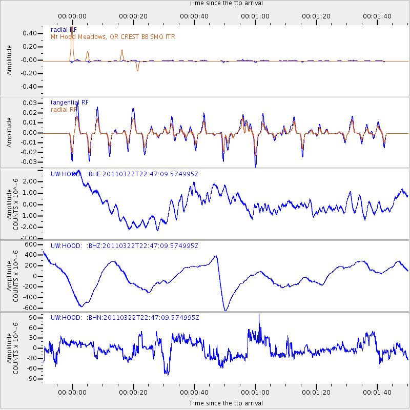
HOOD Mt Hood Meadows, OR CREST BB SMO - Earthquake Result Viewer
*The percent match for this event was below the threshold and hence no stack was calculated.
| Earthquake location: |
Eastern Honshu, Japan |
| Earthquake latitude/longitude: |
37.1/140.6 |
| Earthquake time(UTC): |
2011/03/22 (081) 22:36:32 GMT |
| Earthquake Depth: |
16 km |
| Earthquake Magnitude: |
5.5 MB, 5.2 MS, 5.4 MW, 5.2 MW |
| Earthquake Catalog/Contributor: |
WHDF/NEIC |
|
| Network: |
UW Pacific Northwest Regional Seismic Network |
| Station: |
HOOD Mt Hood Meadows, OR CREST BB SMO |
| Lat/Lon: |
45.32 N/121.65 W |
| Elevation: |
1520 m |
|
| Distance: |
69.6 deg |
| Az: |
48.242 deg |
| Baz: |
302.29 deg |
| Ray Param: |
$rayparam |
*The percent match for this event was below the threshold and hence was not used in the summary stack. |
|
| Radial Match: |
40.237606 % |
| Radial Bump: |
400 |
| Transverse Match: |
41.103153 % |
| Transverse Bump: |
400 |
| SOD ConfigId: |
356183 |
| Insert Time: |
2011-08-19 00:08:14.941 +0000 |
| GWidth: |
2.5 |
| Max Bumps: |
400 |
| Tol: |
0.001 |
|
Signal To Noise
| Channel | StoN | STA | LTA |
| UW:HOOD: :BHZ:20110322T22:47:09.574995Z | 2.23773 | 6.444078E-4 | 2.8797387E-4 |
| UW:HOOD: :BHN:20110322T22:47:09.574995Z | 1.0296656 | 2.9741841E-5 | 2.8884951E-5 |
| UW:HOOD: :BHE:20110322T22:47:09.574995Z | 0.6665598 | 1.0828877E-6 | 1.6245921E-6 |
| Arrivals |
| Ps | |
| PpPs | |
| PsPs/PpSs | |


