You are here: Home > Network List > XL12 - Hangay Dome, Mongolia Stations List
> Station HD73 HD73 > Earthquake Result Viewer
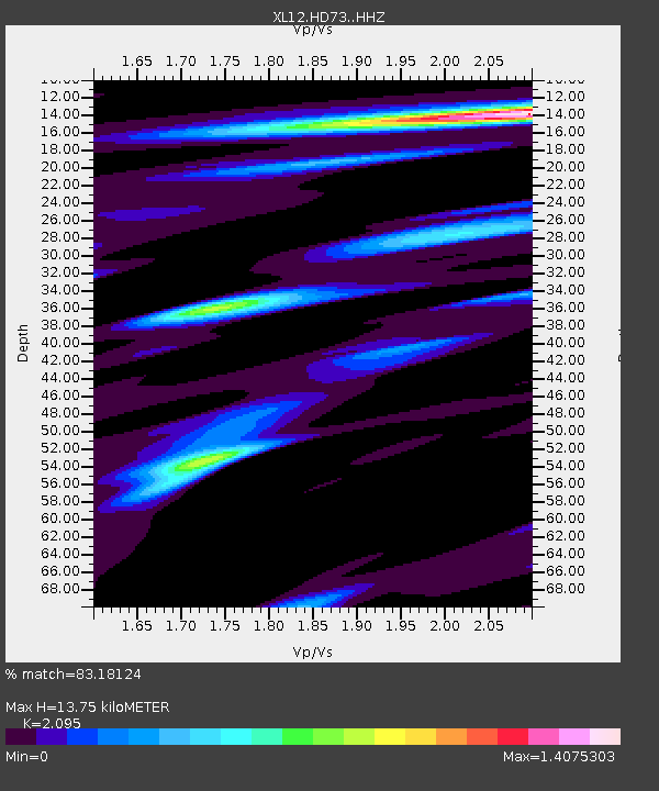
HD73 HD73 - Earthquake Result Viewer
| Earthquake location: |
Northern Sumatra, Indonesia |
| Earthquake latitude/longitude: |
1.2/97.3 |
| Earthquake time(UTC): |
2014/02/22 (053) 17:29:51 GMT |
| Earthquake Depth: |
29 km |
| Earthquake Magnitude: |
5.4 MW |
| Earthquake Catalog/Contributor: |
ISC/ISC |
|
| Network: |
XL Hangay Dome, Mongolia |
| Station: |
HD73 HD73 |
| Lat/Lon: |
49.50 N/101.36 E |
| Elevation: |
1168 m |
|
| Distance: |
48.3 deg |
| Az: |
3.563 deg |
| Baz: |
185.468 deg |
| Ray Param: |
0.06942572 |
| Estimated Moho Depth: |
13.75 km |
| Estimated Crust Vp/Vs: |
2.10 |
| Assumed Crust Vp: |
6.642 km/s |
| Estimated Crust Vs: |
3.17 km/s |
| Estimated Crust Poisson's Ratio: |
0.35 |
|
| Radial Match: |
83.18124 % |
| Radial Bump: |
387 |
| Transverse Match: |
67.22092 % |
| Transverse Bump: |
400 |
| SOD ConfigId: |
3390531 |
| Insert Time: |
2019-04-10 10:13:58.849 +0000 |
| GWidth: |
2.5 |
| Max Bumps: |
400 |
| Tol: |
0.001 |
|

Signal To Noise
| Channel | StoN | STA | LTA |
| XL:HD73: :HHZ:20140222T17:37:58.840006Z | 6.5692863 | 3.8036688E-7 | 5.790079E-8 |
| XL:HD73: :HHN:20140222T17:37:58.840006Z | 6.9093614 | 2.1072208E-7 | 3.0498054E-8 |
| XL:HD73: :HHE:20140222T17:37:58.840006Z | 1.9936626 | 5.6572702E-8 | 2.8376267E-8 |
| Arrivals |
| Ps | 2.4 SECOND |
| PpPs | 6.1 SECOND |
| PsPs/PpSs | 8.5 SECOND |


