You are here: Home > Network List > TA - USArray Transportable Network (new EarthScope stations) Stations List
> Station W34A Bridge Creek, Tuttle, OK, USA > Earthquake Result Viewer
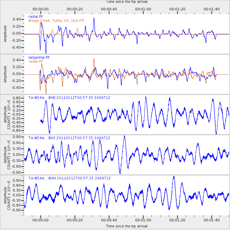
W34A Bridge Creek, Tuttle, OK, USA - Earthquake Result Viewer
*The percent match for this event was below the threshold and hence no stack was calculated.
| Earthquake location: |
Near East Coast Of Honshu, Japan |
| Earthquake latitude/longitude: |
36.1/141.8 |
| Earthquake time(UTC): |
2011/03/12 (071) 00:45:09 GMT |
| Earthquake Depth: |
20 km |
| Earthquake Magnitude: |
5.5 MB, 5.1 MS |
| Earthquake Catalog/Contributor: |
WHDF/NEIC |
|
| Network: |
TA USArray Transportable Network (new EarthScope stations) |
| Station: |
W34A Bridge Creek, Tuttle, OK, USA |
| Lat/Lon: |
35.24 N/97.77 W |
| Elevation: |
428 m |
|
| Distance: |
89.9 deg |
| Az: |
44.881 deg |
| Baz: |
315.734 deg |
| Ray Param: |
$rayparam |
*The percent match for this event was below the threshold and hence was not used in the summary stack. |
|
| Radial Match: |
70.04637 % |
| Radial Bump: |
400 |
| Transverse Match: |
49.72574 % |
| Transverse Bump: |
373 |
| SOD ConfigId: |
356183 |
| Insert Time: |
2011-08-19 00:52:21.117 +0000 |
| GWidth: |
2.5 |
| Max Bumps: |
400 |
| Tol: |
0.001 |
|
Signal To Noise
| Channel | StoN | STA | LTA |
| TA:W34A: :BHZ:20110312T00:57:35.399971Z | 0.85918975 | 2.1576128E-7 | 2.511218E-7 |
| TA:W34A: :BHN:20110312T00:57:35.399971Z | 0.47585678 | 2.1563345E-7 | 4.5314778E-7 |
| TA:W34A: :BHE:20110312T00:57:35.399971Z | 0.8417288 | 2.5485815E-7 | 3.027794E-7 |
| Arrivals |
| Ps | |
| PpPs | |
| PsPs/PpSs | |


