You are here: Home > Network List > CI - Caltech Regional Seismic Network Stations List
> Station BAR Barrett, Tecate, CA, USA > Earthquake Result Viewer
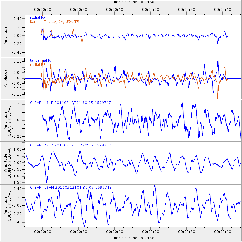
BAR Barrett, Tecate, CA, USA - Earthquake Result Viewer
*The percent match for this event was below the threshold and hence no stack was calculated.
| Earthquake location: |
Tonga Islands |
| Earthquake latitude/longitude: |
-16.7/-173.2 |
| Earthquake time(UTC): |
2011/03/12 (071) 01:19:07 GMT |
| Earthquake Depth: |
14 km |
| Earthquake Magnitude: |
5.7 MB, 6.0 MS, 5.8 MW |
| Earthquake Catalog/Contributor: |
WHDF/NEIC |
|
| Network: |
CI Caltech Regional Seismic Network |
| Station: |
BAR Barrett, Tecate, CA, USA |
| Lat/Lon: |
32.68 N/116.67 W |
| Elevation: |
521 m |
|
| Distance: |
73.0 deg |
| Az: |
47.355 deg |
| Baz: |
236.696 deg |
| Ray Param: |
$rayparam |
*The percent match for this event was below the threshold and hence was not used in the summary stack. |
|
| Radial Match: |
72.21449 % |
| Radial Bump: |
400 |
| Transverse Match: |
45.345627 % |
| Transverse Bump: |
400 |
| SOD ConfigId: |
356183 |
| Insert Time: |
2011-08-19 01:27:59.539 +0000 |
| GWidth: |
2.5 |
| Max Bumps: |
400 |
| Tol: |
0.001 |
|
Signal To Noise
| Channel | StoN | STA | LTA |
| CI:BAR: :BHZ:20110312T01:30:05.169971Z | 2.9350903 | 7.1022583E-7 | 2.419775E-7 |
| CI:BAR: :BHN:20110312T01:30:05.169971Z | 0.7964913 | 1.6709353E-7 | 2.0978702E-7 |
| CI:BAR: :BHE:20110312T01:30:05.169971Z | 0.90401435 | 8.779464E-8 | 9.711642E-8 |
| Arrivals |
| Ps | |
| PpPs | |
| PsPs/PpSs | |


