You are here: Home > Network List > CI - Caltech Regional Seismic Network Stations List
> Station HEC Hector, Baker, CA, USA > Earthquake Result Viewer
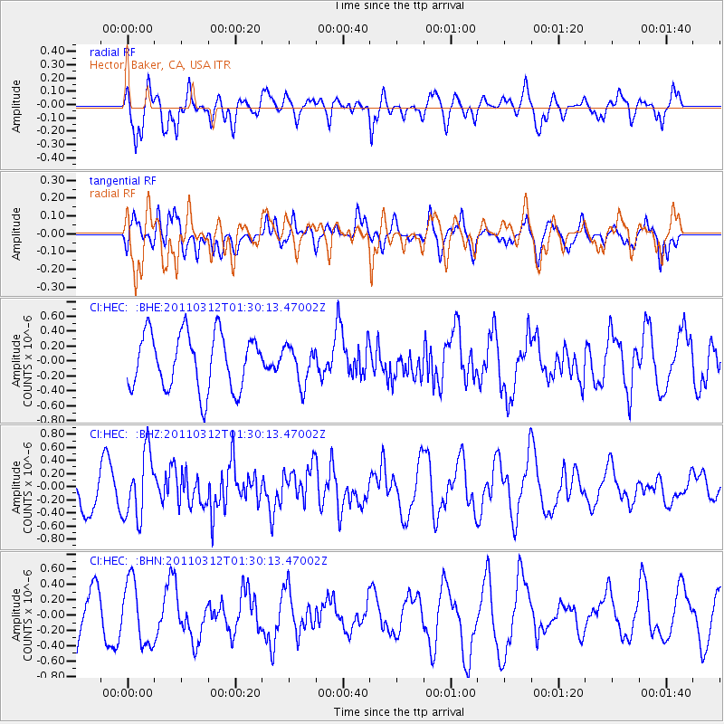
HEC Hector, Baker, CA, USA - Earthquake Result Viewer
*The percent match for this event was below the threshold and hence no stack was calculated.
| Earthquake location: |
Tonga Islands |
| Earthquake latitude/longitude: |
-16.7/-173.2 |
| Earthquake time(UTC): |
2011/03/12 (071) 01:19:07 GMT |
| Earthquake Depth: |
14 km |
| Earthquake Magnitude: |
5.7 MB, 6.0 MS, 5.8 MW |
| Earthquake Catalog/Contributor: |
WHDF/NEIC |
|
| Network: |
CI Caltech Regional Seismic Network |
| Station: |
HEC Hector, Baker, CA, USA |
| Lat/Lon: |
34.83 N/116.33 W |
| Elevation: |
920 m |
|
| Distance: |
74.4 deg |
| Az: |
45.653 deg |
| Baz: |
236.406 deg |
| Ray Param: |
$rayparam |
*The percent match for this event was below the threshold and hence was not used in the summary stack. |
|
| Radial Match: |
73.04696 % |
| Radial Bump: |
394 |
| Transverse Match: |
63.773872 % |
| Transverse Bump: |
400 |
| SOD ConfigId: |
356183 |
| Insert Time: |
2011-08-19 01:31:29.525 +0000 |
| GWidth: |
2.5 |
| Max Bumps: |
400 |
| Tol: |
0.001 |
|
Signal To Noise
| Channel | StoN | STA | LTA |
| CI:HEC: :BHZ:20110312T01:30:13.47002Z | 1.8221692 | 4.9993014E-7 | 2.7435988E-7 |
| CI:HEC: :BHN:20110312T01:30:13.47002Z | 1.5417374 | 4.170667E-7 | 2.7051735E-7 |
| CI:HEC: :BHE:20110312T01:30:13.47002Z | 0.6734729 | 2.5219518E-7 | 3.744697E-7 |
| Arrivals |
| Ps | |
| PpPs | |
| PsPs/PpSs | |


