You are here: Home > Network List > CI - Caltech Regional Seismic Network Stations List
> Station MUR Murrieta > Earthquake Result Viewer
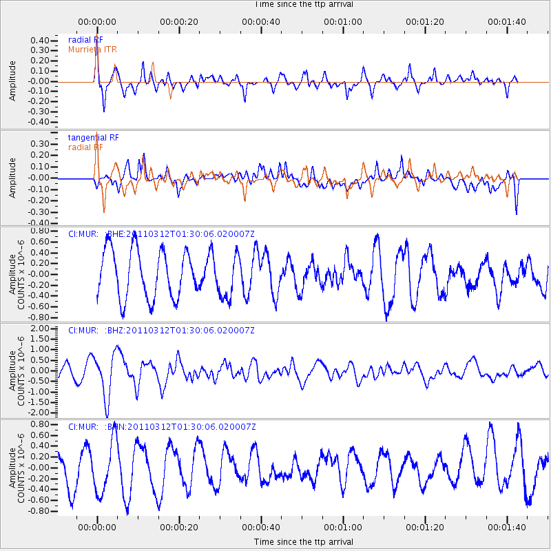
MUR Murrieta - Earthquake Result Viewer
*The percent match for this event was below the threshold and hence no stack was calculated.
| Earthquake location: |
Tonga Islands |
| Earthquake latitude/longitude: |
-16.7/-173.2 |
| Earthquake time(UTC): |
2011/03/12 (071) 01:19:07 GMT |
| Earthquake Depth: |
14 km |
| Earthquake Magnitude: |
5.7 MB, 6.0 MS, 5.8 MW |
| Earthquake Catalog/Contributor: |
WHDF/NEIC |
|
| Network: |
CI Caltech Regional Seismic Network |
| Station: |
MUR Murrieta |
| Lat/Lon: |
33.60 N/117.20 W |
| Elevation: |
562 m |
|
| Distance: |
73.2 deg |
| Az: |
46.302 deg |
| Baz: |
236.105 deg |
| Ray Param: |
$rayparam |
*The percent match for this event was below the threshold and hence was not used in the summary stack. |
|
| Radial Match: |
72.78392 % |
| Radial Bump: |
377 |
| Transverse Match: |
55.426155 % |
| Transverse Bump: |
400 |
| SOD ConfigId: |
356183 |
| Insert Time: |
2011-08-19 01:35:26.692 +0000 |
| GWidth: |
2.5 |
| Max Bumps: |
400 |
| Tol: |
0.001 |
|
Signal To Noise
| Channel | StoN | STA | LTA |
| CI:MUR: :BHZ:20110312T01:30:06.020007Z | 3.4002764 | 1.0512211E-6 | 3.0915754E-7 |
| CI:MUR: :BHN:20110312T01:30:06.020007Z | 2.1070828 | 4.90924E-7 | 2.3298749E-7 |
| CI:MUR: :BHE:20110312T01:30:06.020007Z | 0.89604646 | 3.9502603E-7 | 4.4085442E-7 |
| Arrivals |
| Ps | |
| PpPs | |
| PsPs/PpSs | |


