You are here: Home > Network List > TA - USArray Transportable Network (new EarthScope stations) Stations List
> Station V34A Guthrie, OK, USA > Earthquake Result Viewer
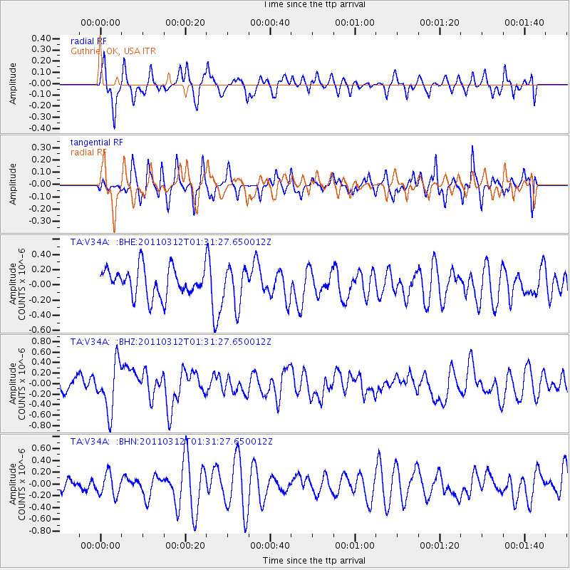
V34A Guthrie, OK, USA - Earthquake Result Viewer
*The percent match for this event was below the threshold and hence no stack was calculated.
| Earthquake location: |
Tonga Islands |
| Earthquake latitude/longitude: |
-16.7/-173.2 |
| Earthquake time(UTC): |
2011/03/12 (071) 01:19:07 GMT |
| Earthquake Depth: |
14 km |
| Earthquake Magnitude: |
5.7 MB, 6.0 MS, 5.8 MW |
| Earthquake Catalog/Contributor: |
WHDF/NEIC |
|
| Network: |
TA USArray Transportable Network (new EarthScope stations) |
| Station: |
V34A Guthrie, OK, USA |
| Lat/Lon: |
35.83 N/97.52 W |
| Elevation: |
329 m |
|
| Distance: |
88.5 deg |
| Az: |
51.963 deg |
| Baz: |
248.248 deg |
| Ray Param: |
$rayparam |
*The percent match for this event was below the threshold and hence was not used in the summary stack. |
|
| Radial Match: |
54.433064 % |
| Radial Bump: |
335 |
| Transverse Match: |
44.725853 % |
| Transverse Bump: |
257 |
| SOD ConfigId: |
356183 |
| Insert Time: |
2011-08-19 02:11:36.358 +0000 |
| GWidth: |
2.5 |
| Max Bumps: |
400 |
| Tol: |
0.001 |
|
Signal To Noise
| Channel | StoN | STA | LTA |
| TA:V34A: :BHZ:20110312T01:31:27.650012Z | 2.3789942 | 4.676111E-7 | 1.9655832E-7 |
| TA:V34A: :BHN:20110312T01:31:27.650012Z | 0.66191834 | 1.8986702E-7 | 2.8684357E-7 |
| TA:V34A: :BHE:20110312T01:31:27.650012Z | 1.3678854 | 2.514676E-7 | 1.8383676E-7 |
| Arrivals |
| Ps | |
| PpPs | |
| PsPs/PpSs | |


