You are here: Home > Network List > TA - USArray Transportable Network (new EarthScope stations) Stations List
> Station 534A Blanco, TX, USA > Earthquake Result Viewer
534A Blanco, TX, USA - Earthquake Result Viewer
| Earthquake location: |
Tonga Islands |
| Earthquake latitude/longitude: |
-16.7/-173.2 |
| Earthquake time(UTC): |
2011/03/12 (071) 01:19:07 GMT |
| Earthquake Depth: |
14 km |
| Earthquake Magnitude: |
5.7 MB, 6.0 MS, 5.8 MW |
| Earthquake Catalog/Contributor: |
WHDF/NEIC |
|
| Network: |
TA USArray Transportable Network (new EarthScope stations) |
| Station: |
534A Blanco, TX, USA |
| Lat/Lon: |
30.03 N/98.48 W |
| Elevation: |
461 m |
|
| Distance: |
85.6 deg |
| Az: |
57.042 deg |
| Baz: |
247.989 deg |
| Ray Param: |
0.04463072 |
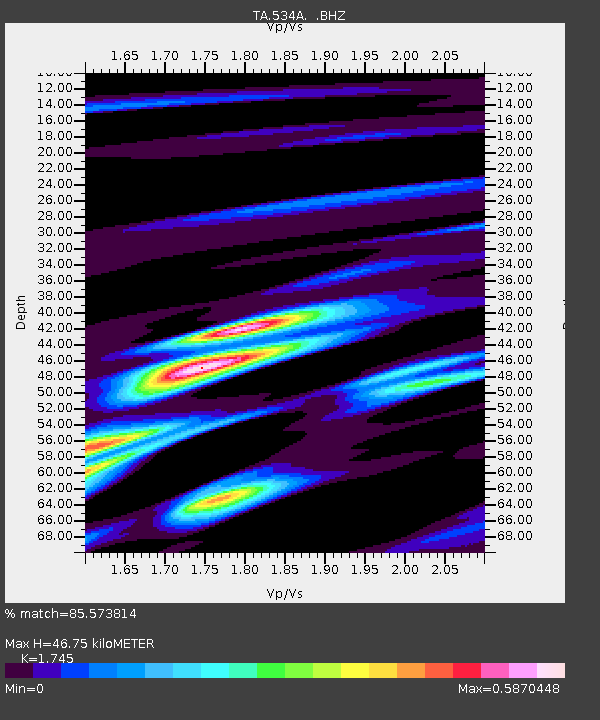
| Estimated Moho Depth: |
46.75 km |
| Estimated Crust Vp/Vs: |
1.75 |
| Assumed Crust Vp: |
6.498 km/s |
| Estimated Crust Vs: |
3.724 km/s |
| Estimated Crust Poisson's Ratio: |
0.26 |
|
| Radial Match: |
85.573814 % |
| Radial Bump: |
400 |
| Transverse Match: |
74.74062 % |
| Transverse Bump: |
378 |
| SOD ConfigId: |
356183 |
| Insert Time: |
2011-08-19 02:12:36.487 +0000 |
| GWidth: |
2.5 |
| Max Bumps: |
400 |
| Tol: |
0.001 |
|

Signal To Noise
| Channel | StoN | STA | LTA |
| TA:534A: :BHZ:20110312T01:31:13.575Z | 8.803544 | 8.080417E-7 | 9.178596E-8 |
| TA:534A: :BHN:20110312T01:31:13.575Z | 2.344612 | 1.4618163E-7 | 6.23479E-8 |
| TA:534A: :BHE:20110312T01:31:13.575Z | 4.087859 | 3.0051936E-7 | 7.351509E-8 |
| Arrivals |
| Ps | 5.5 SECOND |
| PpPs | 19 SECOND |
| PsPs/PpSs | 25 SECOND |


