You are here: Home > Network List > TA - USArray Transportable Network (new EarthScope stations) Stations List
> Station P59A Jarrettsville, MD, USA > Earthquake Result Viewer
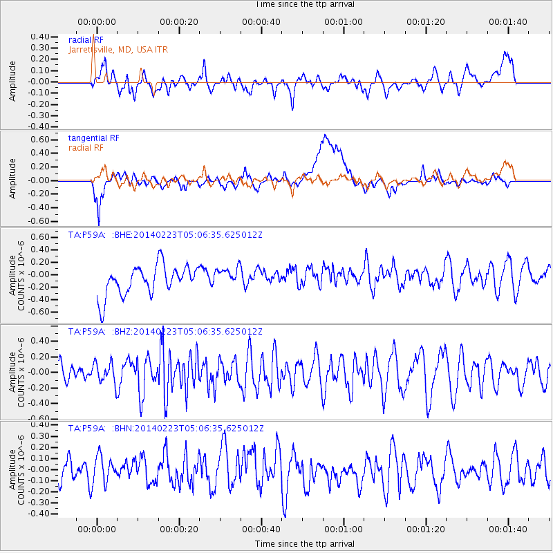
P59A Jarrettsville, MD, USA - Earthquake Result Viewer
*The percent match for this event was below the threshold and hence no stack was calculated.
| Earthquake location: |
Kuril Islands |
| Earthquake latitude/longitude: |
43.5/147.8 |
| Earthquake time(UTC): |
2014/02/23 (054) 04:54:18 GMT |
| Earthquake Depth: |
20 km |
| Earthquake Magnitude: |
5.5 MWC, 5.3 MWB, 5.5 MWC |
| Earthquake Catalog/Contributor: |
NEIC PDE/NEIC COMCAT |
|
| Network: |
TA USArray Transportable Network (new EarthScope stations) |
| Station: |
P59A Jarrettsville, MD, USA |
| Lat/Lon: |
39.61 N/76.43 W |
| Elevation: |
157 m |
|
| Distance: |
88.1 deg |
| Az: |
32.609 deg |
| Baz: |
329.499 deg |
| Ray Param: |
$rayparam |
*The percent match for this event was below the threshold and hence was not used in the summary stack. |
|
| Radial Match: |
43.25284 % |
| Radial Bump: |
400 |
| Transverse Match: |
53.931656 % |
| Transverse Bump: |
400 |
| SOD ConfigId: |
3390531 |
| Insert Time: |
2019-04-10 10:25:11.002 +0000 |
| GWidth: |
2.5 |
| Max Bumps: |
400 |
| Tol: |
0.001 |
|
Signal To Noise
| Channel | StoN | STA | LTA |
| TA:P59A: :BHZ:20140223T05:06:35.625012Z | 0.6820652 | 1.4203611E-7 | 2.0824419E-7 |
| TA:P59A: :BHN:20140223T05:06:35.625012Z | 0.68554866 | 1.3300834E-7 | 1.9401735E-7 |
| TA:P59A: :BHE:20140223T05:06:35.625012Z | 0.63137954 | 1.4637224E-7 | 2.3182923E-7 |
| Arrivals |
| Ps | |
| PpPs | |
| PsPs/PpSs | |


