You are here: Home > Network List > CI - Caltech Regional Seismic Network Stations List
> Station LGU Laguna Peak, California, USA > Earthquake Result Viewer
LGU Laguna Peak, California, USA - Earthquake Result Viewer
| Earthquake location: |
Sea Of Japan |
| Earthquake latitude/longitude: |
36.8/135.5 |
| Earthquake time(UTC): |
2000/06/06 (158) 21:16:42 GMT |
| Earthquake Depth: |
10 km |
| Earthquake Magnitude: |
5.7 MB, 5.3 MS, 5.9 MW, 5.8 MW |
| Earthquake Catalog/Contributor: |
WHDF/NEIC |
|
| Network: |
CI Caltech Regional Seismic Network |
| Station: |
LGU Laguna Peak, California, USA |
| Lat/Lon: |
34.11 N/119.07 W |
| Elevation: |
381 m |
|
| Distance: |
81.1 deg |
| Az: |
54.049 deg |
| Baz: |
308.481 deg |
| Ray Param: |
0.04785929 |
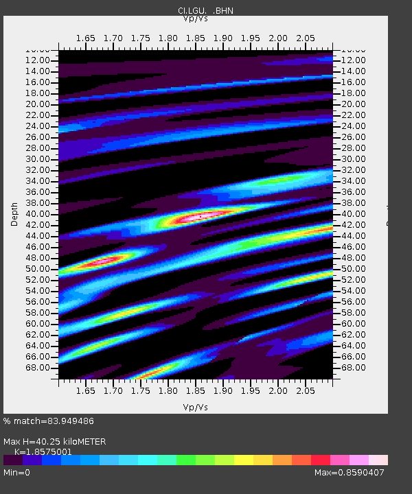
| Estimated Moho Depth: |
40.25 km |
| Estimated Crust Vp/Vs: |
1.86 |
| Assumed Crust Vp: |
6.1 km/s |
| Estimated Crust Vs: |
3.284 km/s |
| Estimated Crust Poisson's Ratio: |
0.30 |
|
| Radial Match: |
83.949486 % |
| Radial Bump: |
400 |
| Transverse Match: |
63.887833 % |
| Transverse Bump: |
400 |
| SOD ConfigId: |
3753 |
| Insert Time: |
2010-02-25 20:13:59.195 +0000 |
| GWidth: |
2.5 |
| Max Bumps: |
400 |
| Tol: |
0.001 |
|
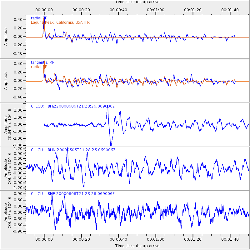
Signal To Noise
| Channel | StoN | STA | LTA |
| CI:LGU: :BHN:20000606T21:28:26.069006Z | 1.4252979 | 3.0376623E-7 | 2.1312472E-7 |
| CI:LGU: :BHE:20000606T21:28:26.069006Z | 1.6721048 | 3.8296508E-7 | 2.2903173E-7 |
| CI:LGU: :BHZ:20000606T21:28:26.069006Z | 7.864689 | 9.283124E-7 | 1.1803549E-7 |
| Arrivals |
| Ps | 5.8 SECOND |
| PpPs | 18 SECOND |
| PsPs/PpSs | 24 SECOND |


