You are here: Home > Network List > US - United States National Seismic Network Stations List
> Station WRAK Wrangell Island, Southeastern Alaska, Alaska, USA > Earthquake Result Viewer
WRAK Wrangell Island, Southeastern Alaska, Alaska, USA - Earthquake Result Viewer
*The percent match for this event was below the threshold and hence no stack was calculated.
| Earthquake location: |
Tonga Islands |
| Earthquake latitude/longitude: |
-16.7/-173.2 |
| Earthquake time(UTC): |
2011/03/12 (071) 01:19:07 GMT |
| Earthquake Depth: |
14 km |
| Earthquake Magnitude: |
5.7 MB, 6.0 MS, 5.8 MW |
| Earthquake Catalog/Contributor: |
WHDF/NEIC |
|
| Network: |
US United States National Seismic Network |
| Station: |
WRAK Wrangell Island, Southeastern Alaska, Alaska, USA |
| Lat/Lon: |
56.42 N/132.35 W |
| Elevation: |
81 m |
|
| Distance: |
80.5 deg |
| Az: |
21.628 deg |
| Baz: |
219.463 deg |
| Ray Param: |
$rayparam |
*The percent match for this event was below the threshold and hence was not used in the summary stack. |
|
| Radial Match: |
65.98175 % |
| Radial Bump: |
400 |
| Transverse Match: |
55.94336 % |
| Transverse Bump: |
400 |
| SOD ConfigId: |
356183 |
| Insert Time: |
2011-08-19 03:09:16.617 +0000 |
| GWidth: |
2.5 |
| Max Bumps: |
400 |
| Tol: |
0.001 |
|
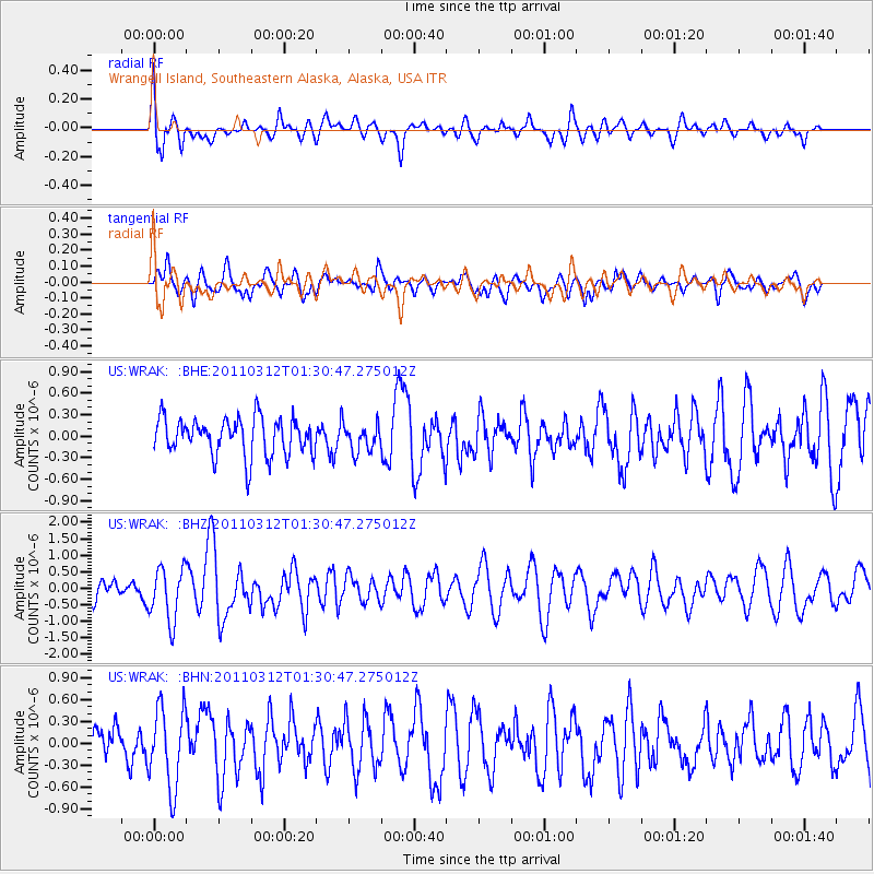
Signal To Noise
| Channel | StoN | STA | LTA |
| US:WRAK: :BHZ:20110312T01:30:47.275012Z | 1.8191185 | 8.019716E-7 | 4.4085726E-7 |
| US:WRAK: :BHN:20110312T01:30:47.275012Z | 2.141206 | 5.4914744E-7 | 2.5646645E-7 |
| US:WRAK: :BHE:20110312T01:30:47.275012Z | 0.7037566 | 1.8408336E-7 | 2.615725E-7 |
| Arrivals |
| Ps | |
| PpPs | |
| PsPs/PpSs | |


