You are here: Home > Network List > TA - USArray Transportable Network (new EarthScope stations) Stations List
> Station K22A Casper, WY, USA > Earthquake Result Viewer
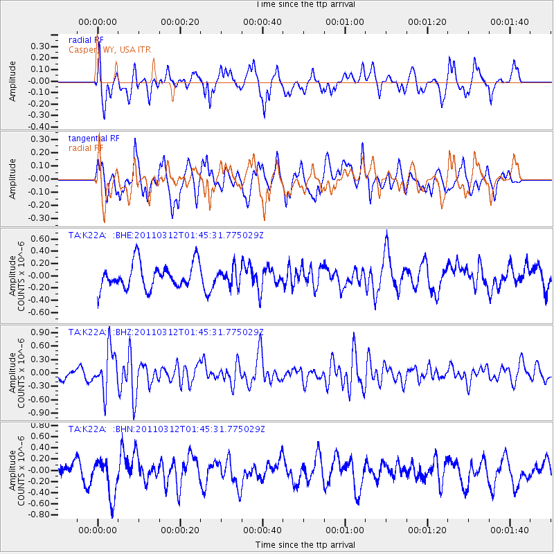
K22A Casper, WY, USA - Earthquake Result Viewer
*The percent match for this event was below the threshold and hence no stack was calculated.
| Earthquake location: |
Near East Coast Of Honshu, Japan |
| Earthquake latitude/longitude: |
38.8/142.8 |
| Earthquake time(UTC): |
2011/03/12 (071) 01:34:09 GMT |
| Earthquake Depth: |
22 km |
| Earthquake Magnitude: |
5.6 MB, 5.9 MS |
| Earthquake Catalog/Contributor: |
WHDF/NEIC |
|
| Network: |
TA USArray Transportable Network (new EarthScope stations) |
| Station: |
K22A Casper, WY, USA |
| Lat/Lon: |
42.65 N/106.52 W |
| Elevation: |
1686 m |
|
| Distance: |
77.4 deg |
| Az: |
45.016 deg |
| Baz: |
311.441 deg |
| Ray Param: |
$rayparam |
*The percent match for this event was below the threshold and hence was not used in the summary stack. |
|
| Radial Match: |
64.54844 % |
| Radial Bump: |
400 |
| Transverse Match: |
67.95563 % |
| Transverse Bump: |
400 |
| SOD ConfigId: |
356183 |
| Insert Time: |
2011-08-19 04:07:33.904 +0000 |
| GWidth: |
2.5 |
| Max Bumps: |
400 |
| Tol: |
0.001 |
|
Signal To Noise
| Channel | StoN | STA | LTA |
| TA:K22A: :BHZ:20110312T01:45:31.775029Z | 3.2731094 | 4.685482E-7 | 1.431508E-7 |
| TA:K22A: :BHN:20110312T01:45:31.775029Z | 3.5109534 | 3.5067234E-7 | 9.9879514E-8 |
| TA:K22A: :BHE:20110312T01:45:31.775029Z | 0.6938605 | 1.4191586E-7 | 2.0453083E-7 |
| Arrivals |
| Ps | |
| PpPs | |
| PsPs/PpSs | |


