You are here: Home > Network List > TA - USArray Transportable Network (new EarthScope stations) Stations List
> Station I27A Quinn, SD, USA > Earthquake Result Viewer
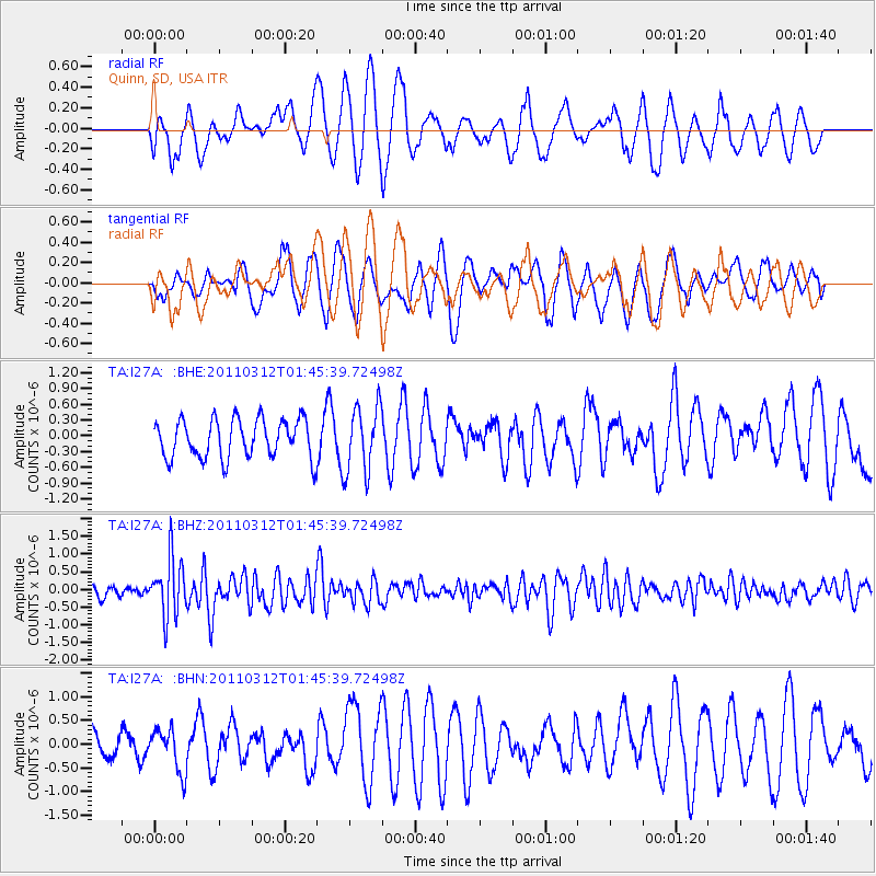
I27A Quinn, SD, USA - Earthquake Result Viewer
*The percent match for this event was below the threshold and hence no stack was calculated.
| Earthquake location: |
Near East Coast Of Honshu, Japan |
| Earthquake latitude/longitude: |
38.8/142.8 |
| Earthquake time(UTC): |
2011/03/12 (071) 01:34:09 GMT |
| Earthquake Depth: |
22 km |
| Earthquake Magnitude: |
5.6 MB, 5.9 MS |
| Earthquake Catalog/Contributor: |
WHDF/NEIC |
|
| Network: |
TA USArray Transportable Network (new EarthScope stations) |
| Station: |
I27A Quinn, SD, USA |
| Lat/Lon: |
44.07 N/102.05 W |
| Elevation: |
867 m |
|
| Distance: |
78.9 deg |
| Az: |
41.695 deg |
| Baz: |
313.819 deg |
| Ray Param: |
$rayparam |
*The percent match for this event was below the threshold and hence was not used in the summary stack. |
|
| Radial Match: |
61.677464 % |
| Radial Bump: |
400 |
| Transverse Match: |
60.521206 % |
| Transverse Bump: |
400 |
| SOD ConfigId: |
356183 |
| Insert Time: |
2011-08-19 04:17:00.180 +0000 |
| GWidth: |
2.5 |
| Max Bumps: |
400 |
| Tol: |
0.001 |
|
Signal To Noise
| Channel | StoN | STA | LTA |
| TA:I27A: :BHZ:20110312T01:45:39.72498Z | 5.058351 | 8.170392E-7 | 1.6152283E-7 |
| TA:I27A: :BHN:20110312T01:45:39.72498Z | 0.8371747 | 4.5517447E-7 | 5.437031E-7 |
| TA:I27A: :BHE:20110312T01:45:39.72498Z | 1.726906 | 6.343931E-7 | 3.673582E-7 |
| Arrivals |
| Ps | |
| PpPs | |
| PsPs/PpSs | |


