You are here: Home > Network List > TA - USArray Transportable Network (new EarthScope stations) Stations List
> Station 533A Kerrville, TX, USA > Earthquake Result Viewer
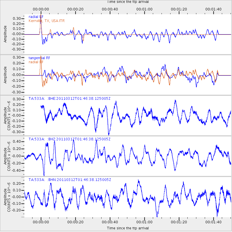
533A Kerrville, TX, USA - Earthquake Result Viewer
*The percent match for this event was below the threshold and hence no stack was calculated.
| Earthquake location: |
Near East Coast Of Honshu, Japan |
| Earthquake latitude/longitude: |
38.8/142.8 |
| Earthquake time(UTC): |
2011/03/12 (071) 01:34:09 GMT |
| Earthquake Depth: |
22 km |
| Earthquake Magnitude: |
5.6 MB, 5.9 MS |
| Earthquake Catalog/Contributor: |
WHDF/NEIC |
|
| Network: |
TA USArray Transportable Network (new EarthScope stations) |
| Station: |
533A Kerrville, TX, USA |
| Lat/Lon: |
30.07 N/99.04 W |
| Elevation: |
556 m |
|
| Distance: |
90.5 deg |
| Az: |
49.859 deg |
| Baz: |
316.405 deg |
| Ray Param: |
$rayparam |
*The percent match for this event was below the threshold and hence was not used in the summary stack. |
|
| Radial Match: |
59.35972 % |
| Radial Bump: |
400 |
| Transverse Match: |
43.256855 % |
| Transverse Bump: |
388 |
| SOD ConfigId: |
356183 |
| Insert Time: |
2011-08-19 04:28:19.822 +0000 |
| GWidth: |
2.5 |
| Max Bumps: |
400 |
| Tol: |
0.001 |
|
Signal To Noise
| Channel | StoN | STA | LTA |
| TA:533A: :BHZ:20110312T01:46:38.125005Z | 3.516987 | 2.5254252E-7 | 7.18065E-8 |
| TA:533A: :BHN:20110312T01:46:38.125005Z | 0.7253608 | 8.493359E-8 | 1.1709151E-7 |
| TA:533A: :BHE:20110312T01:46:38.125005Z | 1.7063578 | 1.4349662E-7 | 8.409527E-8 |
| Arrivals |
| Ps | |
| PpPs | |
| PsPs/PpSs | |


