You are here: Home > Network List > TA - USArray Transportable Network (new EarthScope stations) Stations List
> Station X37A Clayton, OK, USA > Earthquake Result Viewer
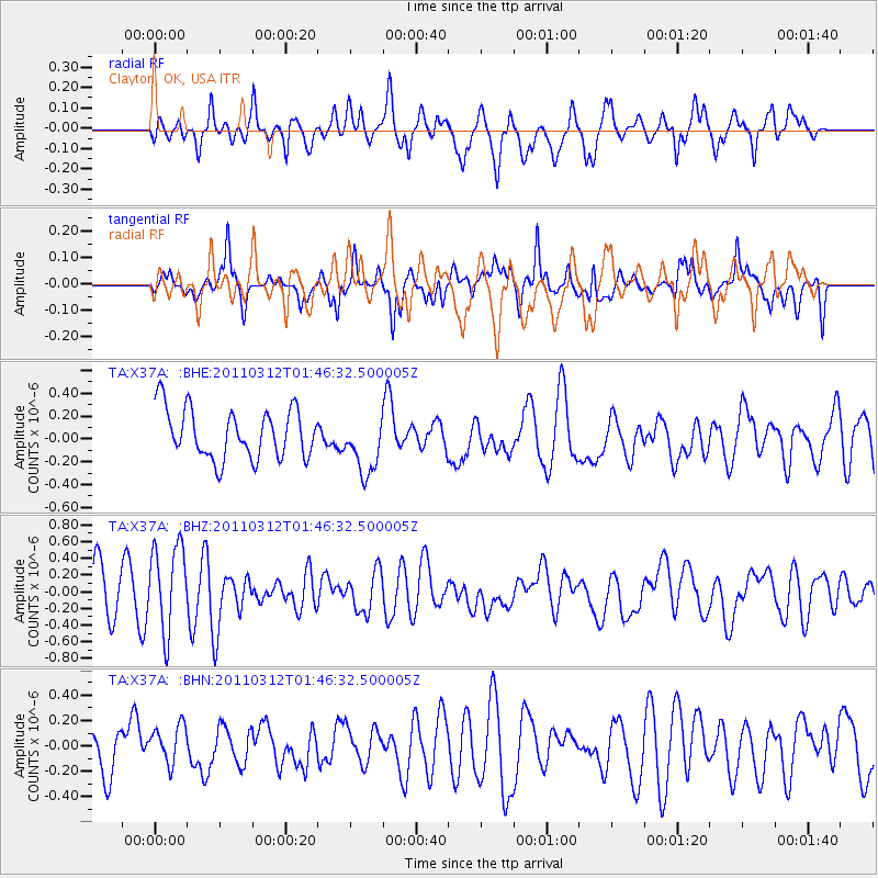
X37A Clayton, OK, USA - Earthquake Result Viewer
*The percent match for this event was below the threshold and hence no stack was calculated.
| Earthquake location: |
Near East Coast Of Honshu, Japan |
| Earthquake latitude/longitude: |
38.8/142.8 |
| Earthquake time(UTC): |
2011/03/12 (071) 01:34:09 GMT |
| Earthquake Depth: |
22 km |
| Earthquake Magnitude: |
5.6 MB, 5.9 MS |
| Earthquake Catalog/Contributor: |
WHDF/NEIC |
|
| Network: |
TA USArray Transportable Network (new EarthScope stations) |
| Station: |
X37A Clayton, OK, USA |
| Lat/Lon: |
34.59 N/95.37 W |
| Elevation: |
207 m |
|
| Distance: |
89.3 deg |
| Az: |
44.527 deg |
| Baz: |
318.347 deg |
| Ray Param: |
$rayparam |
*The percent match for this event was below the threshold and hence was not used in the summary stack. |
|
| Radial Match: |
57.906517 % |
| Radial Bump: |
400 |
| Transverse Match: |
61.18288 % |
| Transverse Bump: |
354 |
| SOD ConfigId: |
356183 |
| Insert Time: |
2011-08-19 04:36:41.369 +0000 |
| GWidth: |
2.5 |
| Max Bumps: |
400 |
| Tol: |
0.001 |
|
Signal To Noise
| Channel | StoN | STA | LTA |
| TA:X37A: :BHZ:20110312T01:46:32.500005Z | 1.7719885 | 5.2790665E-7 | 2.9791764E-7 |
| TA:X37A: :BHN:20110312T01:46:32.500005Z | 0.7273411 | 1.6524307E-7 | 2.2718785E-7 |
| TA:X37A: :BHE:20110312T01:46:32.500005Z | 1.1934988 | 2.5805716E-7 | 2.1621901E-7 |
| Arrivals |
| Ps | |
| PpPs | |
| PsPs/PpSs | |


