You are here: Home > Network List > US - United States National Seismic Network Stations List
> Station EGMT Eagleton, Montana, USA > Earthquake Result Viewer
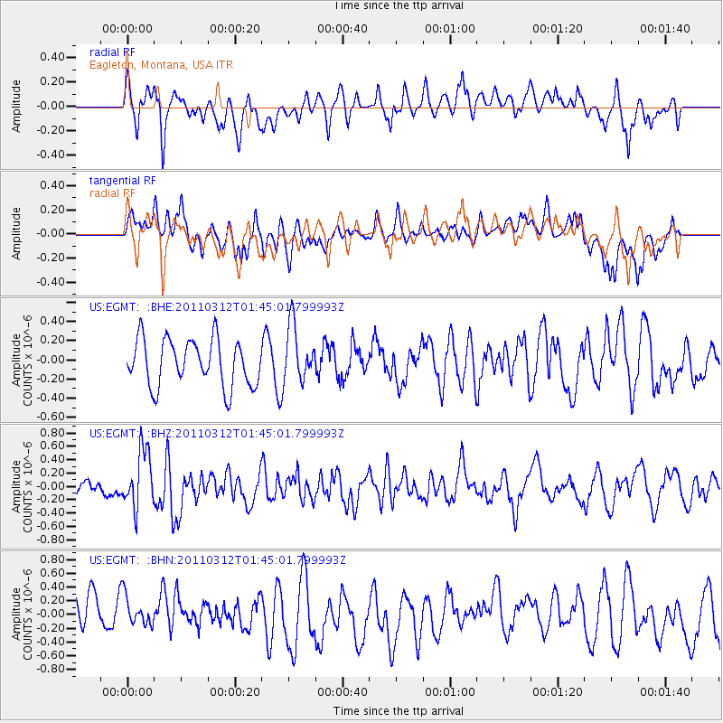
EGMT Eagleton, Montana, USA - Earthquake Result Viewer
*The percent match for this event was below the threshold and hence no stack was calculated.
| Earthquake location: |
Near East Coast Of Honshu, Japan |
| Earthquake latitude/longitude: |
38.8/142.8 |
| Earthquake time(UTC): |
2011/03/12 (071) 01:34:09 GMT |
| Earthquake Depth: |
22 km |
| Earthquake Magnitude: |
5.6 MB, 5.9 MS |
| Earthquake Catalog/Contributor: |
WHDF/NEIC |
|
| Network: |
US United States National Seismic Network |
| Station: |
EGMT Eagleton, Montana, USA |
| Lat/Lon: |
48.02 N/109.75 W |
| Elevation: |
1055 m |
|
| Distance: |
72.2 deg |
| Az: |
42.265 deg |
| Baz: |
308.428 deg |
| Ray Param: |
$rayparam |
*The percent match for this event was below the threshold and hence was not used in the summary stack. |
|
| Radial Match: |
56.43074 % |
| Radial Bump: |
400 |
| Transverse Match: |
59.777576 % |
| Transverse Bump: |
400 |
| SOD ConfigId: |
356183 |
| Insert Time: |
2011-08-19 05:14:19.841 +0000 |
| GWidth: |
2.5 |
| Max Bumps: |
400 |
| Tol: |
0.001 |
|
Signal To Noise
| Channel | StoN | STA | LTA |
| US:EGMT: :BHZ:20110312T01:45:01.799993Z | 3.5828335 | 4.302672E-7 | 1.2009131E-7 |
| US:EGMT: :BHN:20110312T01:45:01.799993Z | 0.86004364 | 2.463725E-7 | 2.864651E-7 |
| US:EGMT: :BHE:20110312T01:45:01.799993Z | 1.2097336 | 2.934836E-7 | 2.4260183E-7 |
| Arrivals |
| Ps | |
| PpPs | |
| PsPs/PpSs | |


