You are here: Home > Network List > TA - USArray Transportable Network (new EarthScope stations) Stations List
> Station R36A Gordon, Harris, KS, USA > Earthquake Result Viewer
R36A Gordon, Harris, KS, USA - Earthquake Result Viewer
| Earthquake location: |
Near East Coast Of Honshu, Japan |
| Earthquake latitude/longitude: |
37.3/141.8 |
| Earthquake time(UTC): |
2011/03/12 (071) 01:46:20 GMT |
| Earthquake Depth: |
32 km |
| Earthquake Magnitude: |
5.5 MB |
| Earthquake Catalog/Contributor: |
WHDF/NEIC |
|
| Network: |
TA USArray Transportable Network (new EarthScope stations) |
| Station: |
R36A Gordon, Harris, KS, USA |
| Lat/Lon: |
38.32 N/95.50 W |
| Elevation: |
354 m |
|
| Distance: |
88.1 deg |
| Az: |
41.449 deg |
| Baz: |
317.866 deg |
| Ray Param: |
0.042822756 |
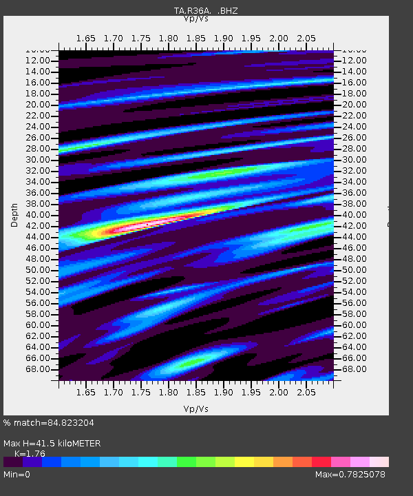
| Estimated Moho Depth: |
41.5 km |
| Estimated Crust Vp/Vs: |
1.76 |
| Assumed Crust Vp: |
6.498 km/s |
| Estimated Crust Vs: |
3.692 km/s |
| Estimated Crust Poisson's Ratio: |
0.26 |
|
| Radial Match: |
84.823204 % |
| Radial Bump: |
400 |
| Transverse Match: |
53.699516 % |
| Transverse Bump: |
400 |
| SOD ConfigId: |
356183 |
| Insert Time: |
2011-08-19 06:11:38.475 +0000 |
| GWidth: |
2.5 |
| Max Bumps: |
400 |
| Tol: |
0.001 |
|
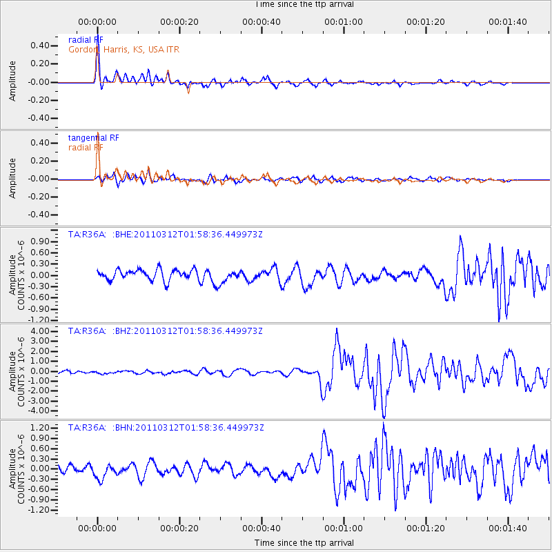
Signal To Noise
| Channel | StoN | STA | LTA |
| TA:R36A: :BHZ:20110312T01:58:36.449973Z | 0.8911893 | 1.0503994E-7 | 1.178649E-7 |
| TA:R36A: :BHN:20110312T01:58:36.449973Z | 1.1785637 | 2.2083374E-7 | 1.873753E-7 |
| TA:R36A: :BHE:20110312T01:58:36.449973Z | 1.4325789 | 1.9399846E-7 | 1.3541903E-7 |
| Arrivals |
| Ps | 5.0 SECOND |
| PpPs | 17 SECOND |
| PsPs/PpSs | 22 SECOND |


